Oil and Natural Gas Exploration, Resources, and Production
U.S. Lower 48 states and North America
Overview maps showing basin and play boundries
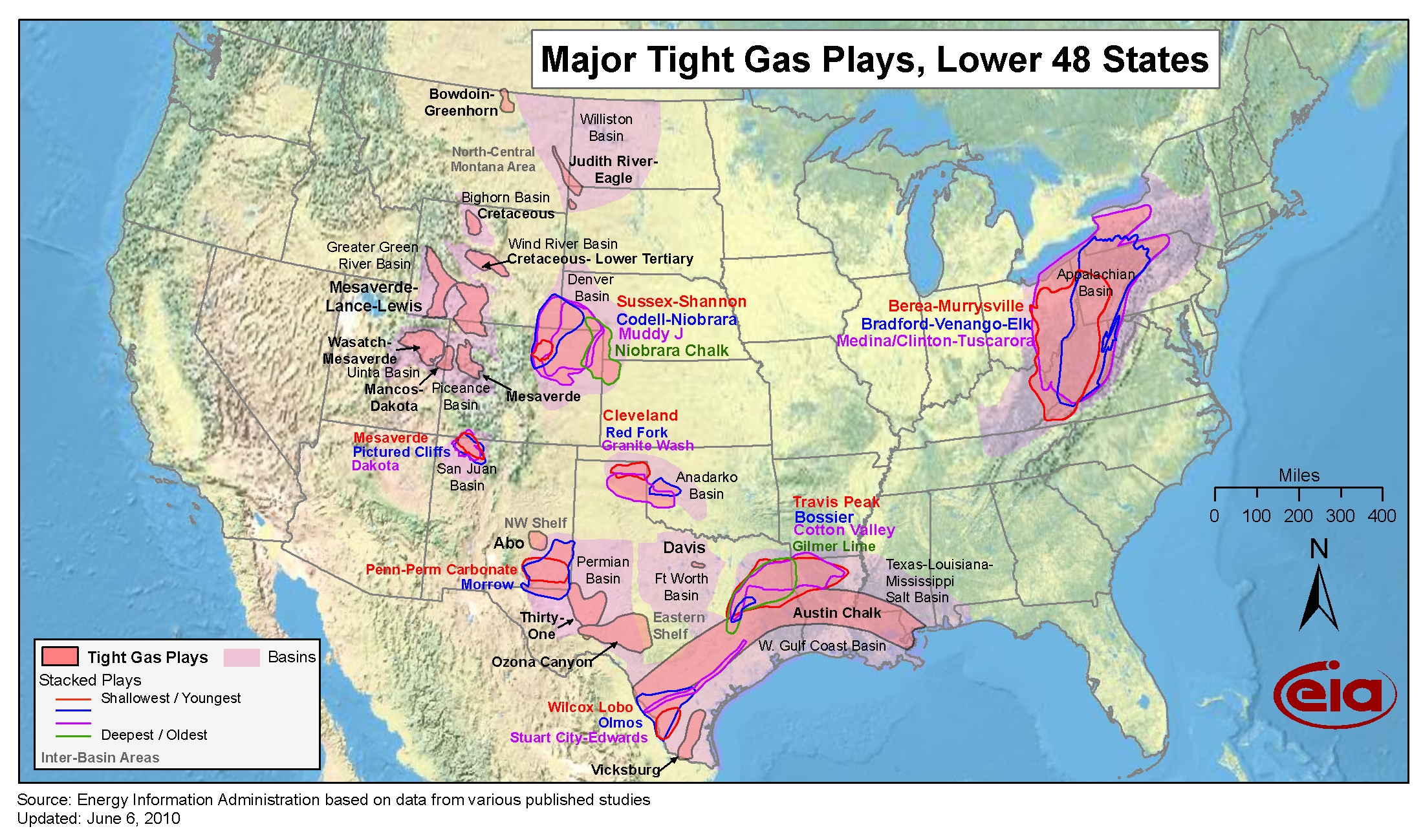
- Shale plays, Lower 48 States
- Release date: December 13, 2023
- Available formats: PDF JPG
- Release date: June 30, 2016
- Available formats: PDF JPG
- Release date: April 13, 2015
- Available formats: PDF JPG
- Map data for Lower 48 states
- Low permeability oil and natural gas play boundaries
- Release date: October 8, 2019
- Available formats: Shapefile
- Sedimentary basin boundaries
- Release date: March 11, 2016
- Available formats: Shapefile
Major U.S. oil and natural gas play detail by basin
Anadarko Basin (OK, TX)
- Granite Wash Play
- Release Date: November 9, 2010
- Available formats: PDF
- Woodford Shale Play
- Release Date: June 1, 2011
- Available formats: PDF
Ardmore Basin (OK, TX)
- Woodford Shale Play
- Release Date: June 1, 2011
- Available formats: PDF
Arkoma Basin (OK, AR)
- Fayetteville Shale, Arkansas
- Release Date: June 1, 2011
- Available formats: PDF PDF(letter-size)
- Woodford Shale Play, Oklahoma
- Release Date: June 1, 2011
- Available formats: PDF
Appalachian Basin (NY, PA, OH, WV, KY)
- Marcellus Play
- Marcellus Play Report: geology review and map updates
- Release date: February 10, 2017
- Available formats: PDF
- Release date: February 8, 2015
- Available formats: PDF
- Today in Energy article: Updated geologic maps provide greater detail for Marcellus formation
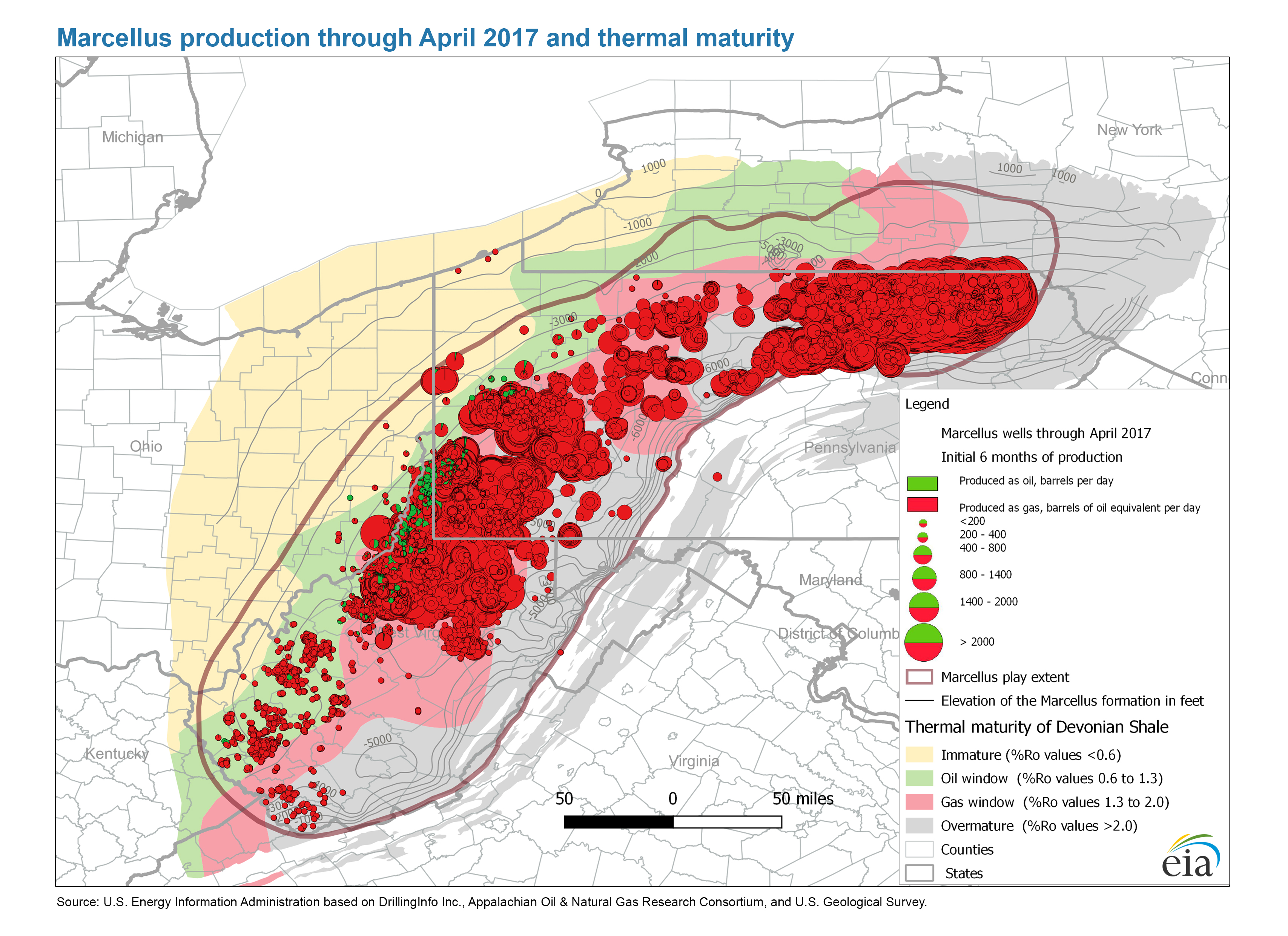
- Marcellus production through April 2017 and thermal maturity
- Release date: April 20, 2015
- Available formats: PDF JPG
- Release date: June 1, 2011
- Available formats: PDF
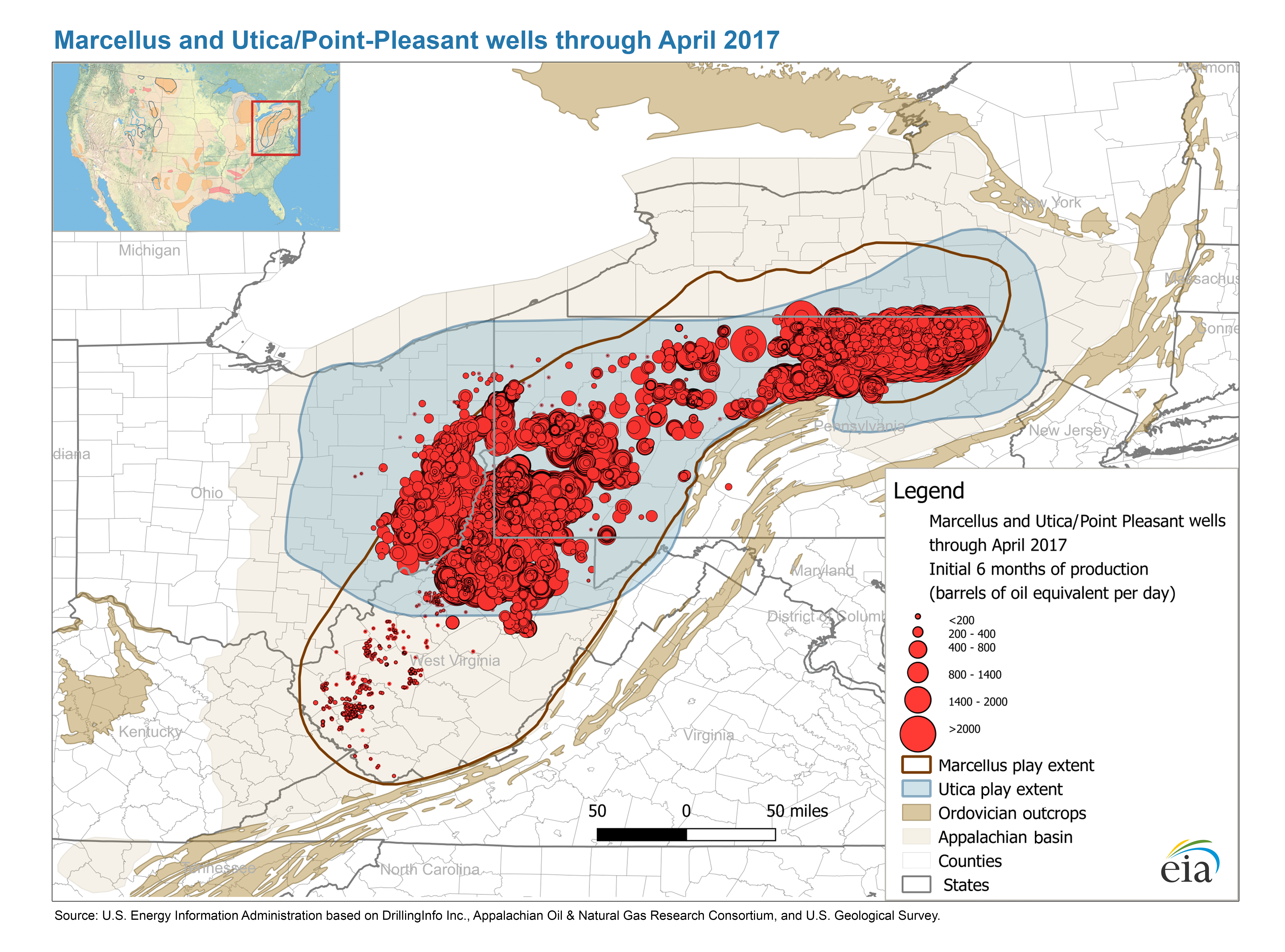
- Marcellus and Utica/Point-Pleasant wells through April 2017
- Release date: February 8, 2015
- Available formats: PDF JPG
- Map data: Marcellus play boundaries, structure and isopachs
- Release date: March 11, 2016
- Available formats: Shapefile
- Utica/Point Pleasant Play
- Utica Play Report: geology review and map updates
- Release date: April 7, 2017
- Available formats: PDF
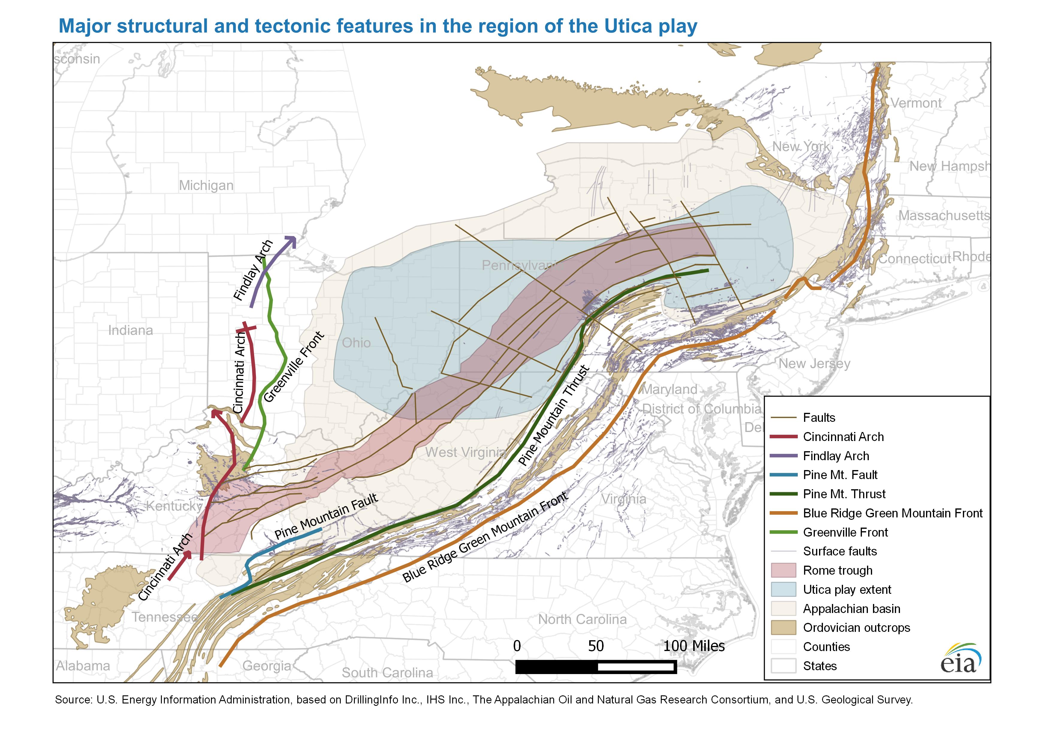
- Major structure map and tectonic features in the region of the Utica play
- Release date: April 19, 2016
- Available formats: PDF JPG
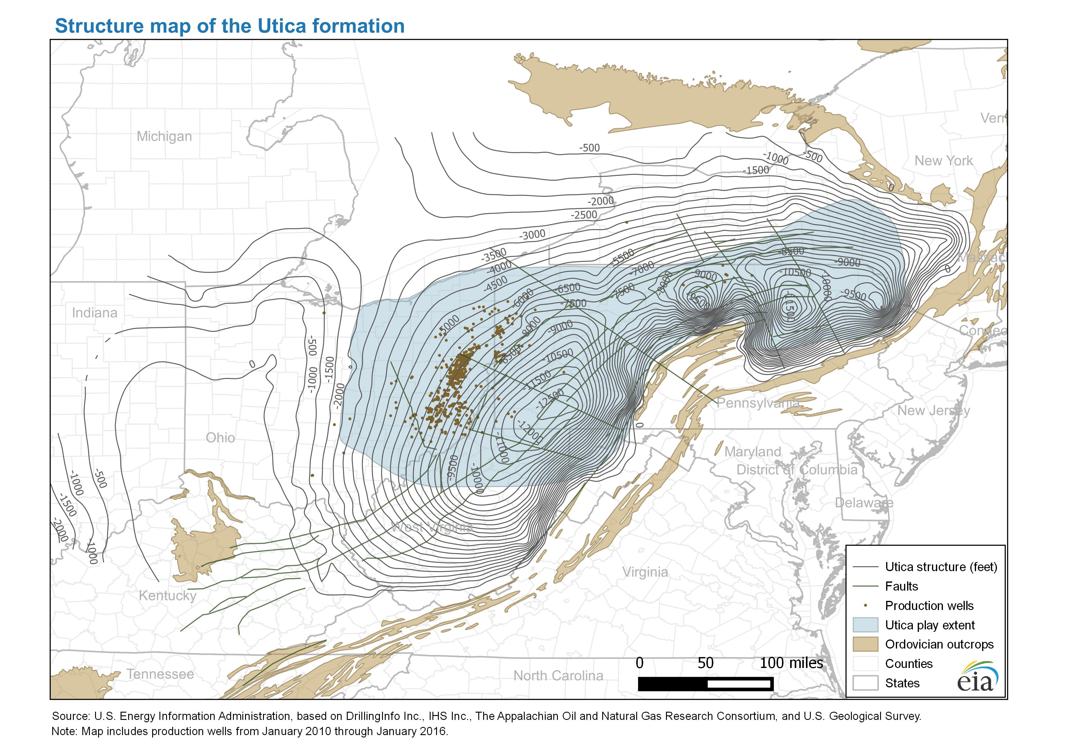
- Structure map of the Utica formation
- Release date: April 19, 2016
- Available formats: PDF JPG
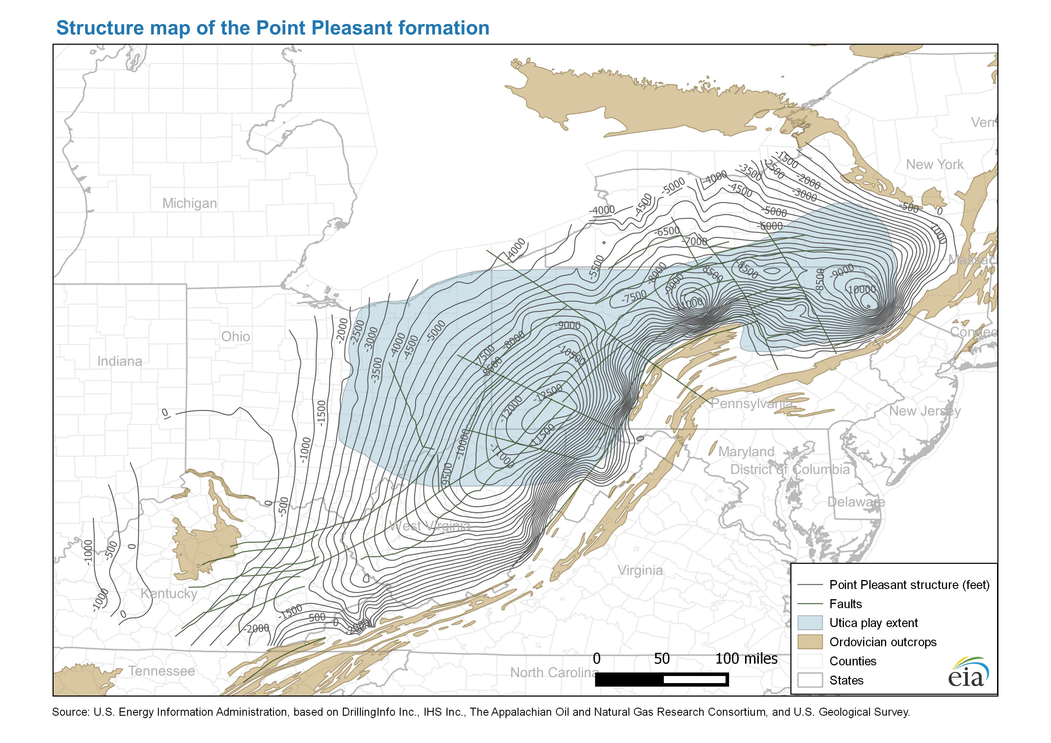
- Structure map of the Point Pleasant formation
- Release date: April 19, 2016
- Available formats: PDF JPG
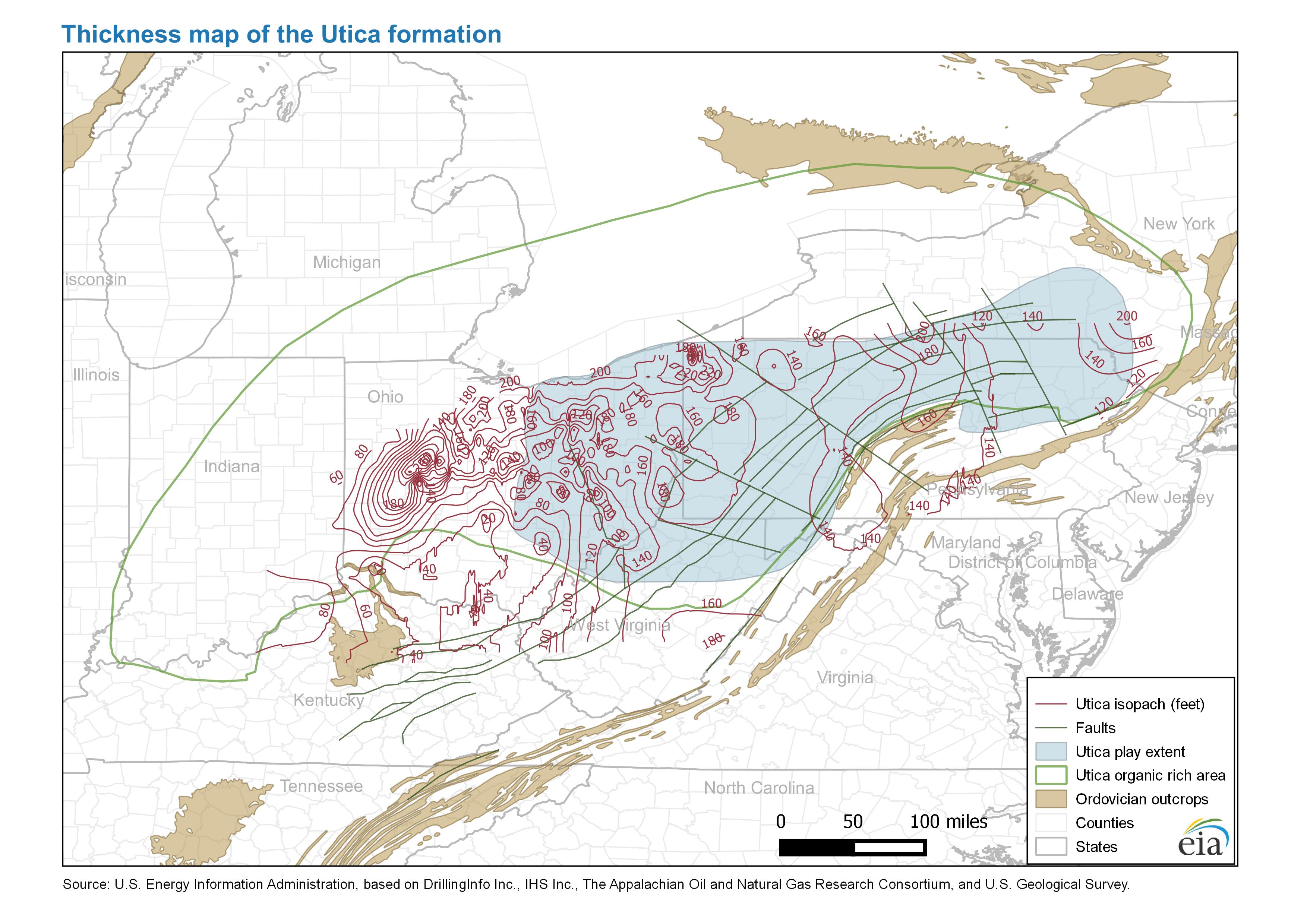
- Thickness map of the Utica formation
- Release date: April 19, 2016
- Available formats: PDF JPG
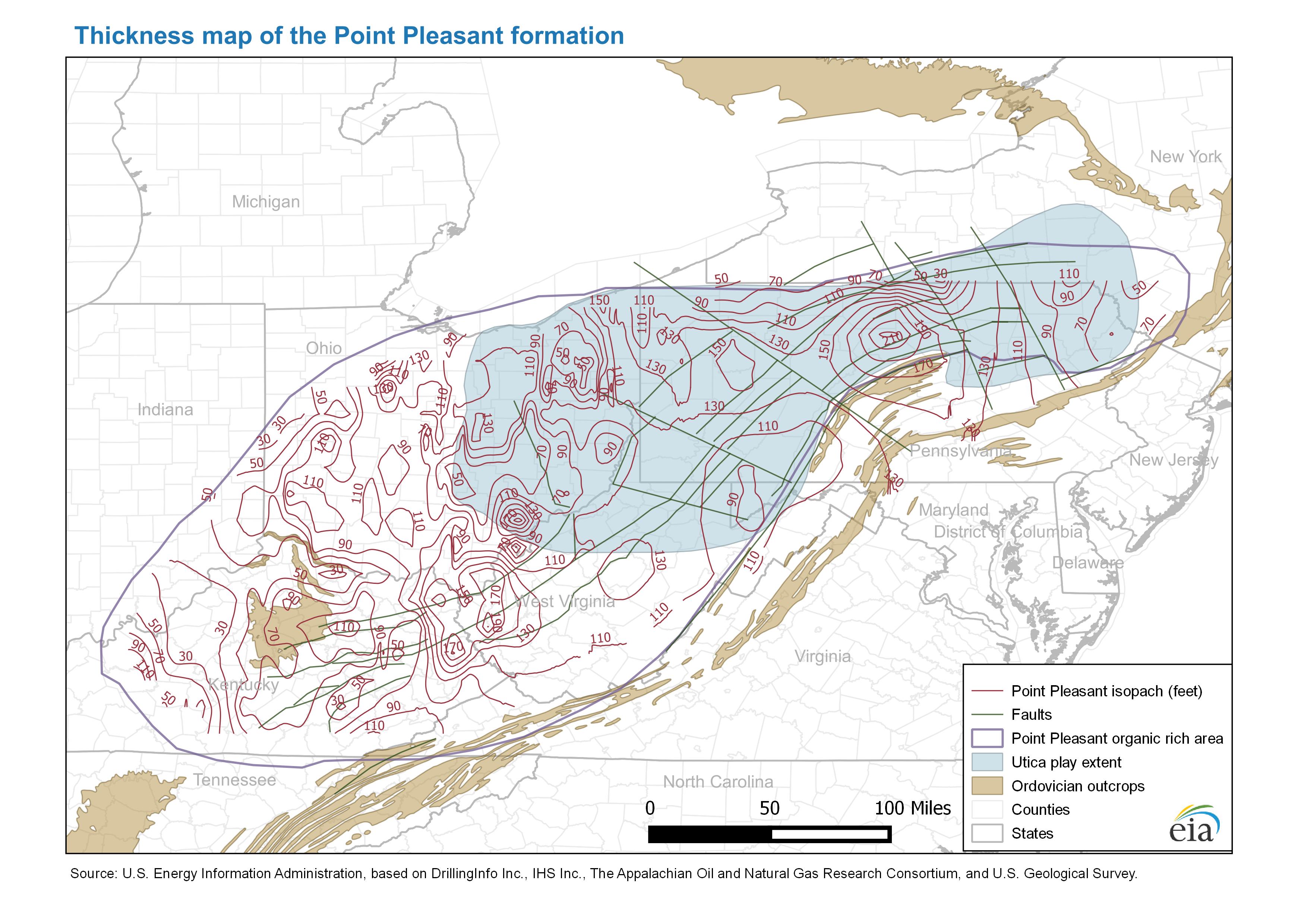
- Thickness map of the Point Pleasant formation
- Release date: April 19, 2016
- Available formats: PDF JPG
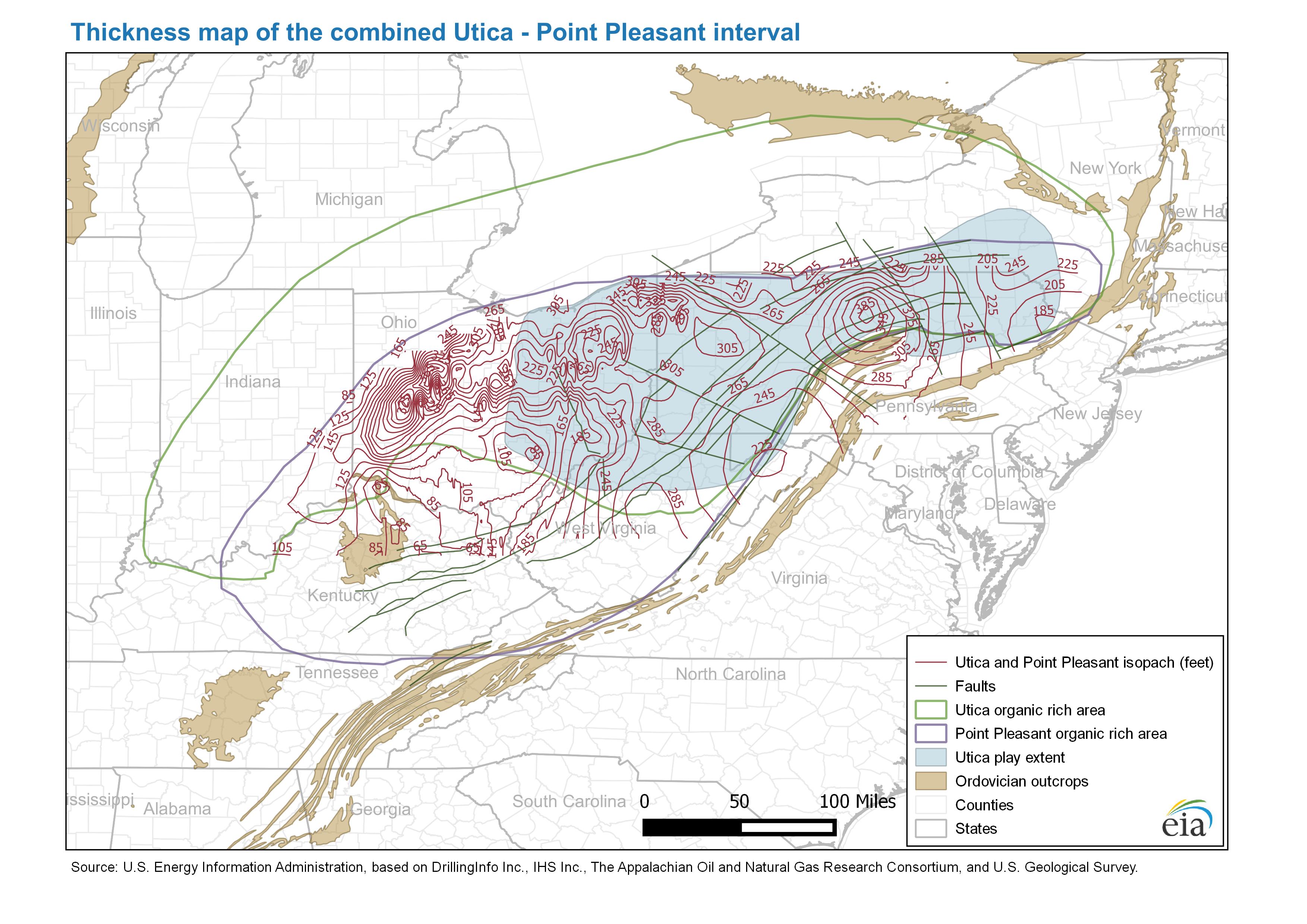
- Thickness map of the combined Utica - Point Pleasant interval
- Release date: April 19, 2016
- Available formats: PDF JPG
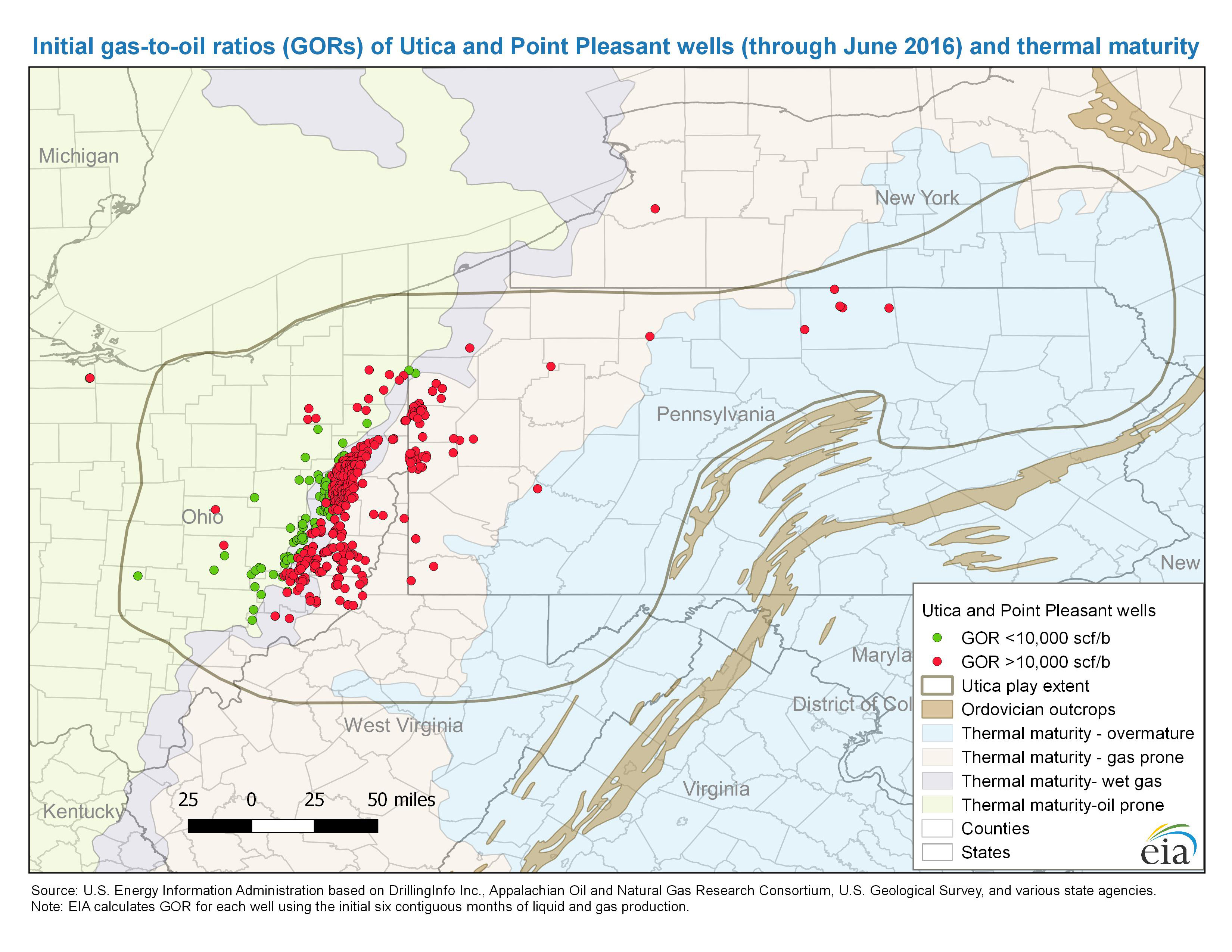
- Initial gas-to-oil ratios (GORs) of Utica and Point Pleasant wells through June 2016 and thermal maturity
- Release date: September 21, 2016
- Available formats: PDF JPG
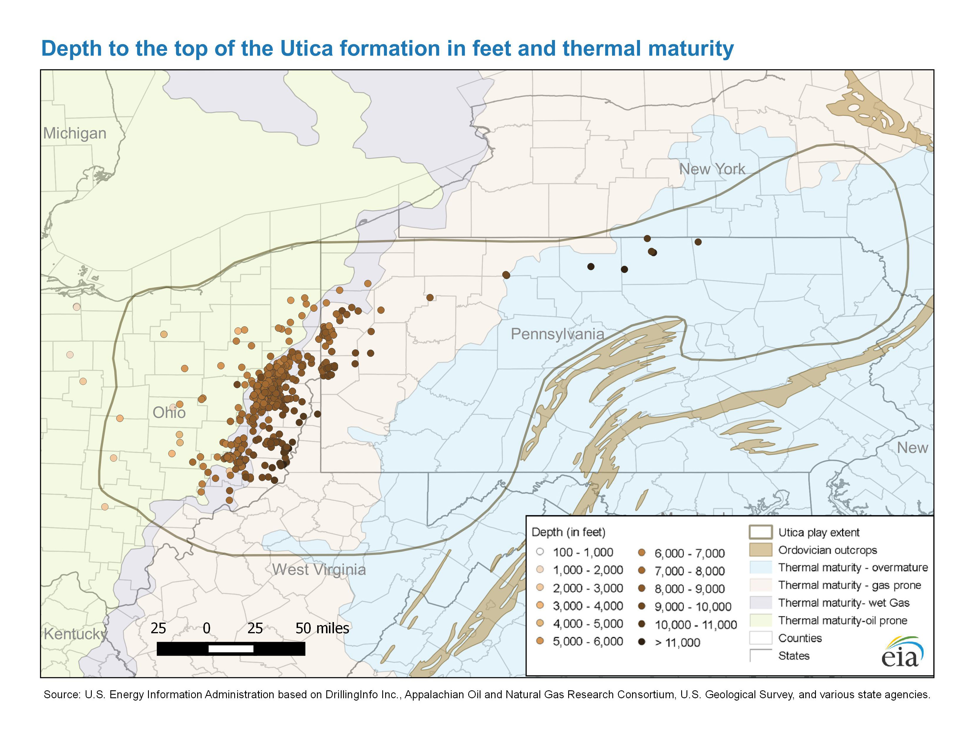
- Depth to the top of the Utica formation in feet and thermal maturity
- Release date: September 21, 2016
- Available formats: PDF JPG
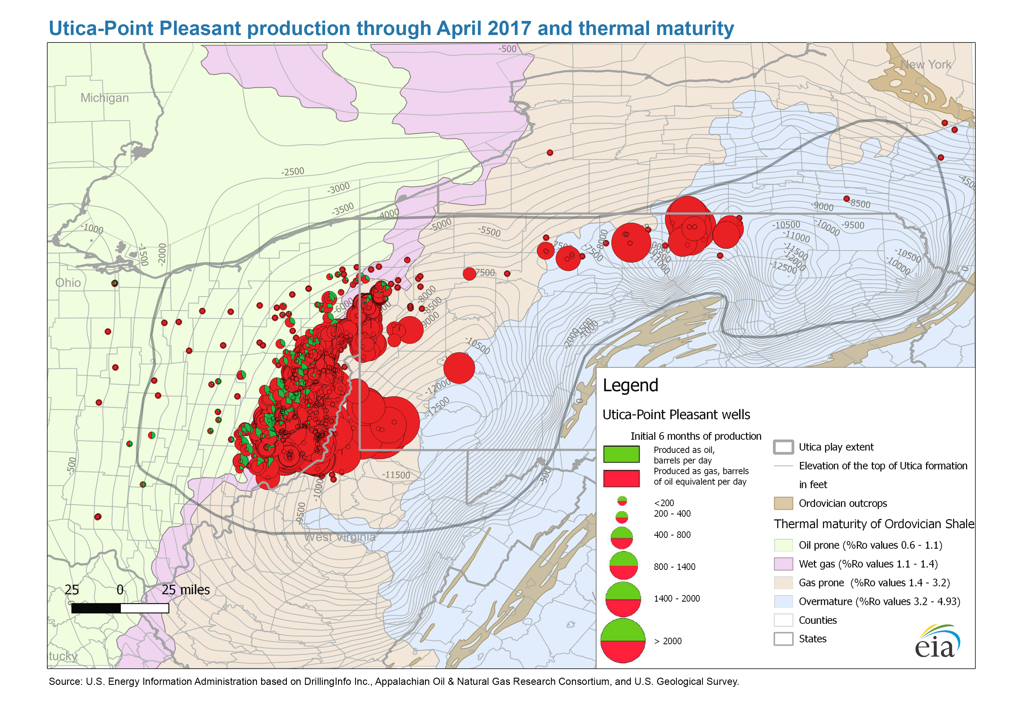
- Utica and Point Pleasant production through April 2017 and thermal maturity
- Release date: April 20, 2017
- Available formats: PDF JPG
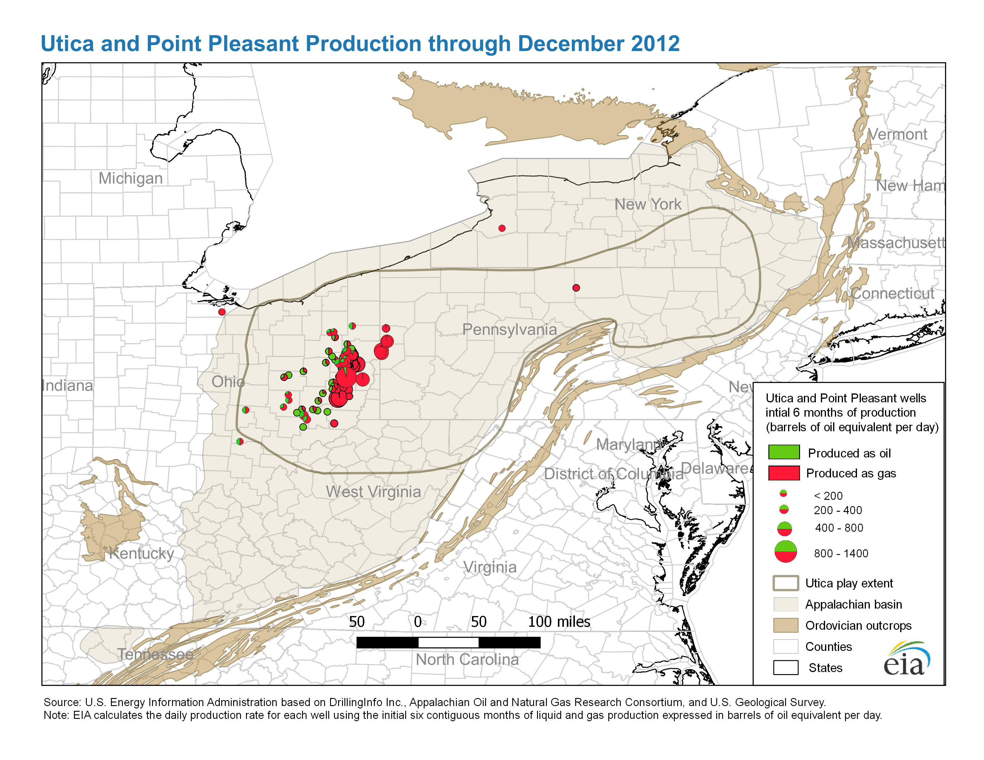
- Utica and Point Pleasant production through December 2012
- Release date: September 21, 2016
- Available formats: PDF JPG
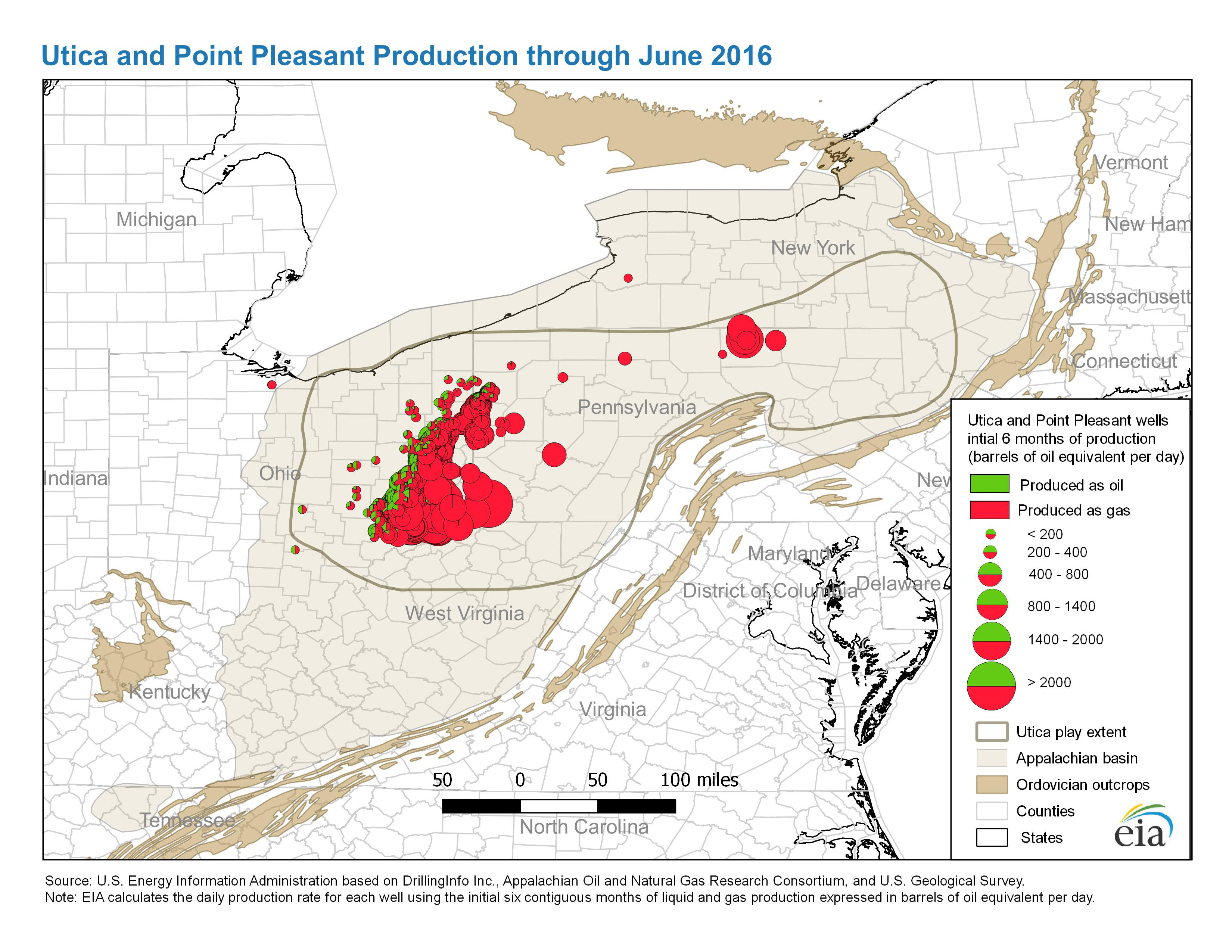
- Utica and Point Pleasant production through June 2016
- Release date: September 21, 2016
- Available formats: PDF JPG
- Map data: play boundaries, structure and Isopach for Utica and Point Pleasant formations
- Release date: May 6, 2016
- Available formats: Shapefile
- Major structural and tectonic features for Utica play
- Release date: May 9, 2016
- Available formats: Shapefile
Ft. Worth Basin (TX)
- Barnett Shale
- Release Date: June 1, 2011
- Available formats: PDF PDF(letter-size)
- History animation: Barnett Shale Drilling, 1981-2010
- Release Date: June 1, 2011
- Available formats: ZIP
Permian Basin (TX, NM)
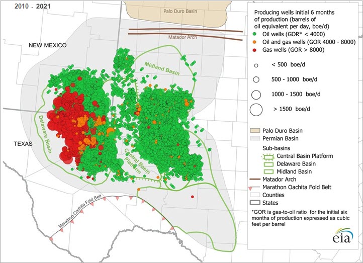
- Permian Basin production January 2010 through December 2021
- Release date: August 30, 2022
- Available formats: JPG ZIP
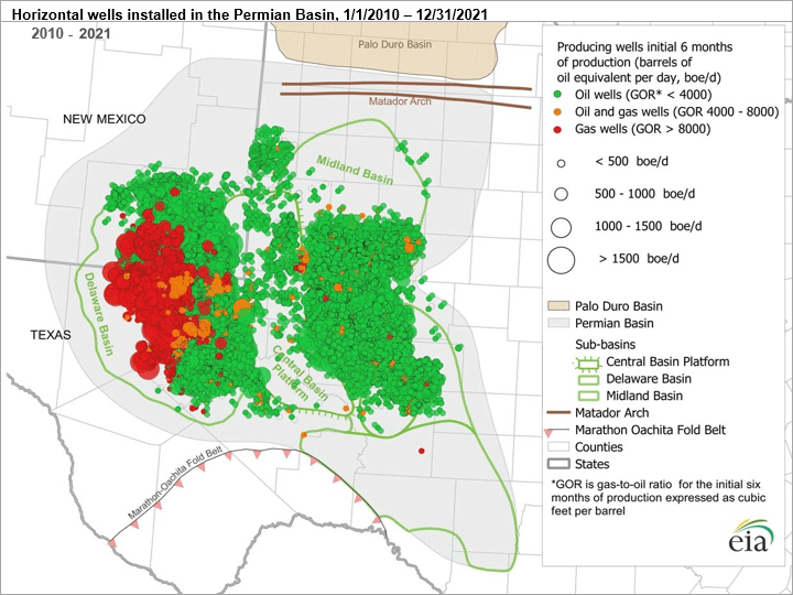
Data source: U.S. Energy Information Administration, based on DrillingInfo- Permian Basin: Part I: Wolfcamp, Bone Spring, Delaware Shale Plays of the Delaware Basin
- Release date: February 13, 2020
- Available formats: PDF
- Permian Basin: Part II: Wolfcamp Shale and Spraberry Plays of the Midland Basin
- Release date: March 30, 2022
- Available formats: PDF
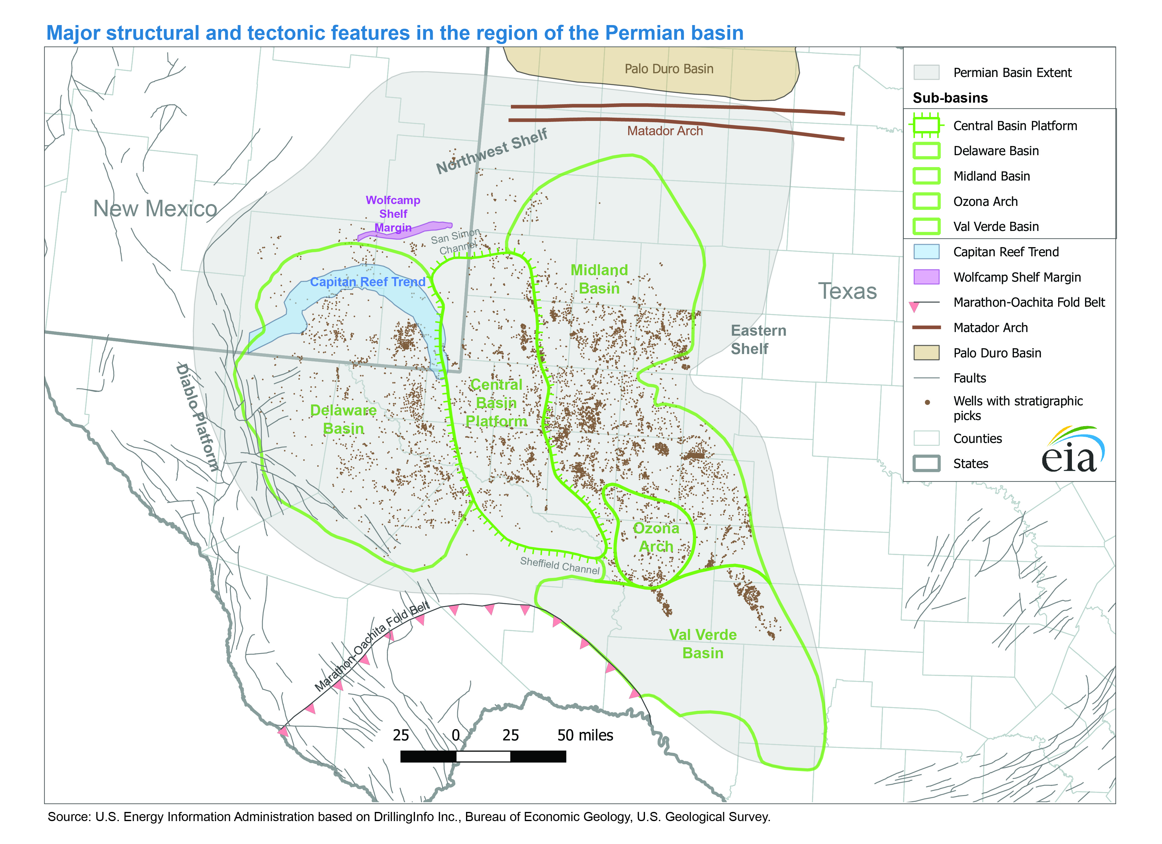
- Major structural and tectonic features of the Permian Basin
- Release date: December 21, 2017
- Available formats: PDF JPG
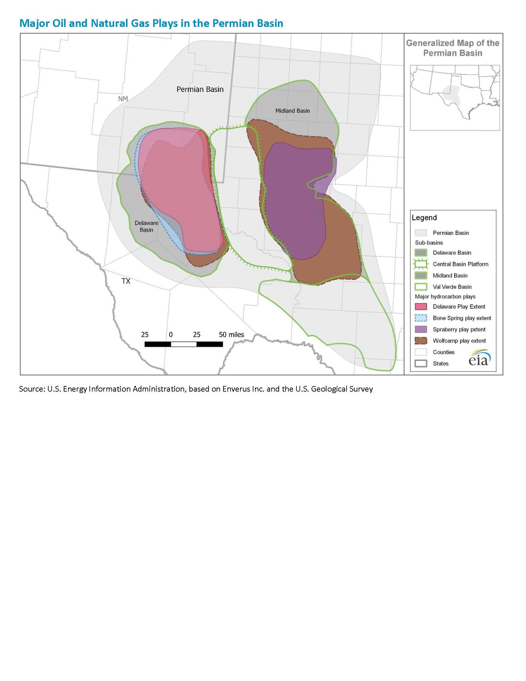
- Major oil and natural gas plays in the Permian Basin
- Release date: October 19, 2021
- Available formats: PDF JPG
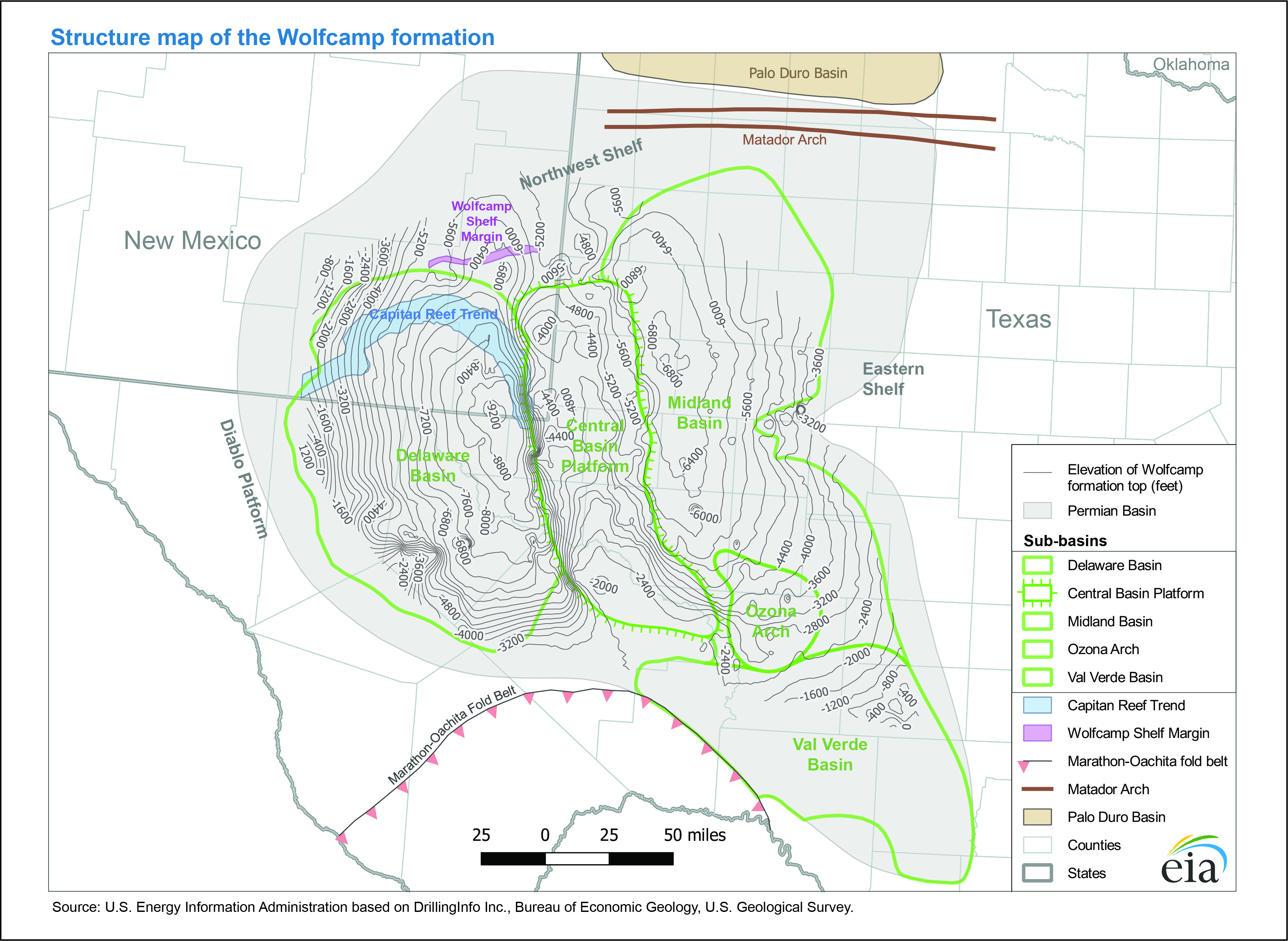
- Structure map of the Wolfcamp formation
- Release date: December 21, 2017
- Available formats: PDF JPG
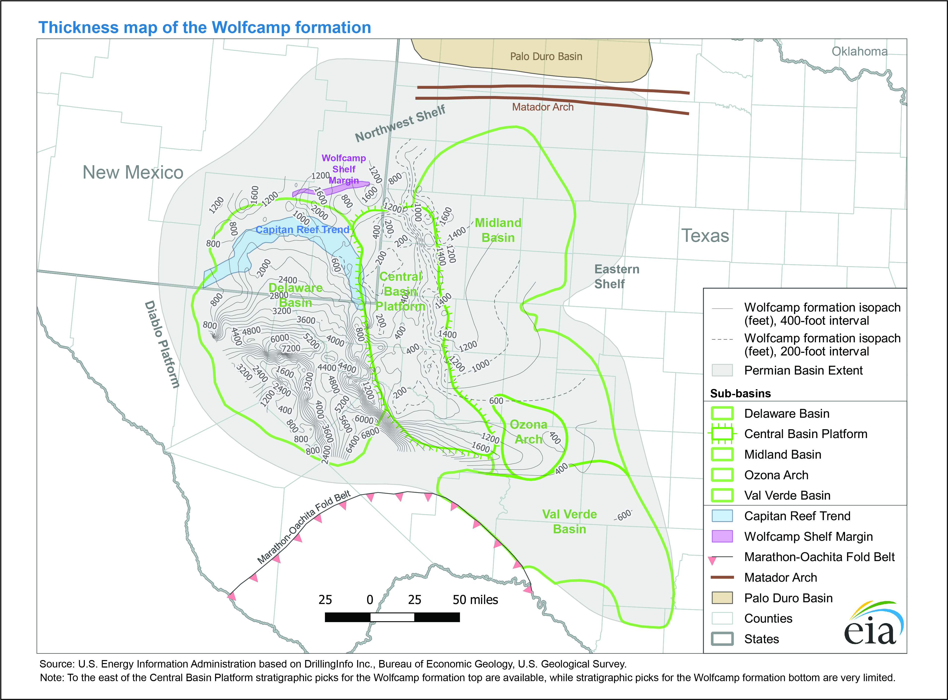
- Thickness map of the Wolfcamp formation
- Release date: December 21, 2017
- Available formats: PDF JPG
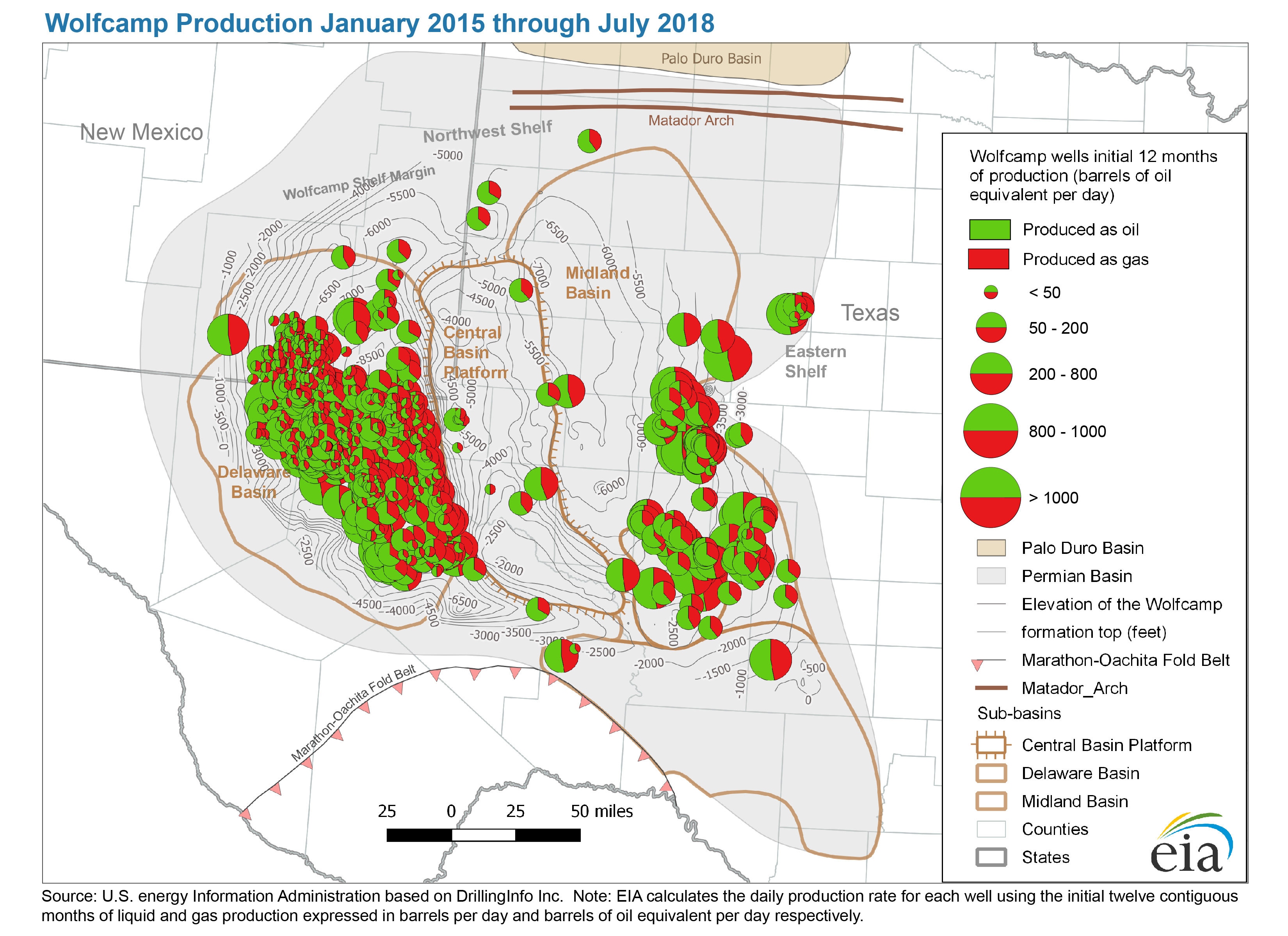
- Wolfcamp production January 2015 through July 2018
- Release date: August 7, 2018
- Available formats: PDF JPG
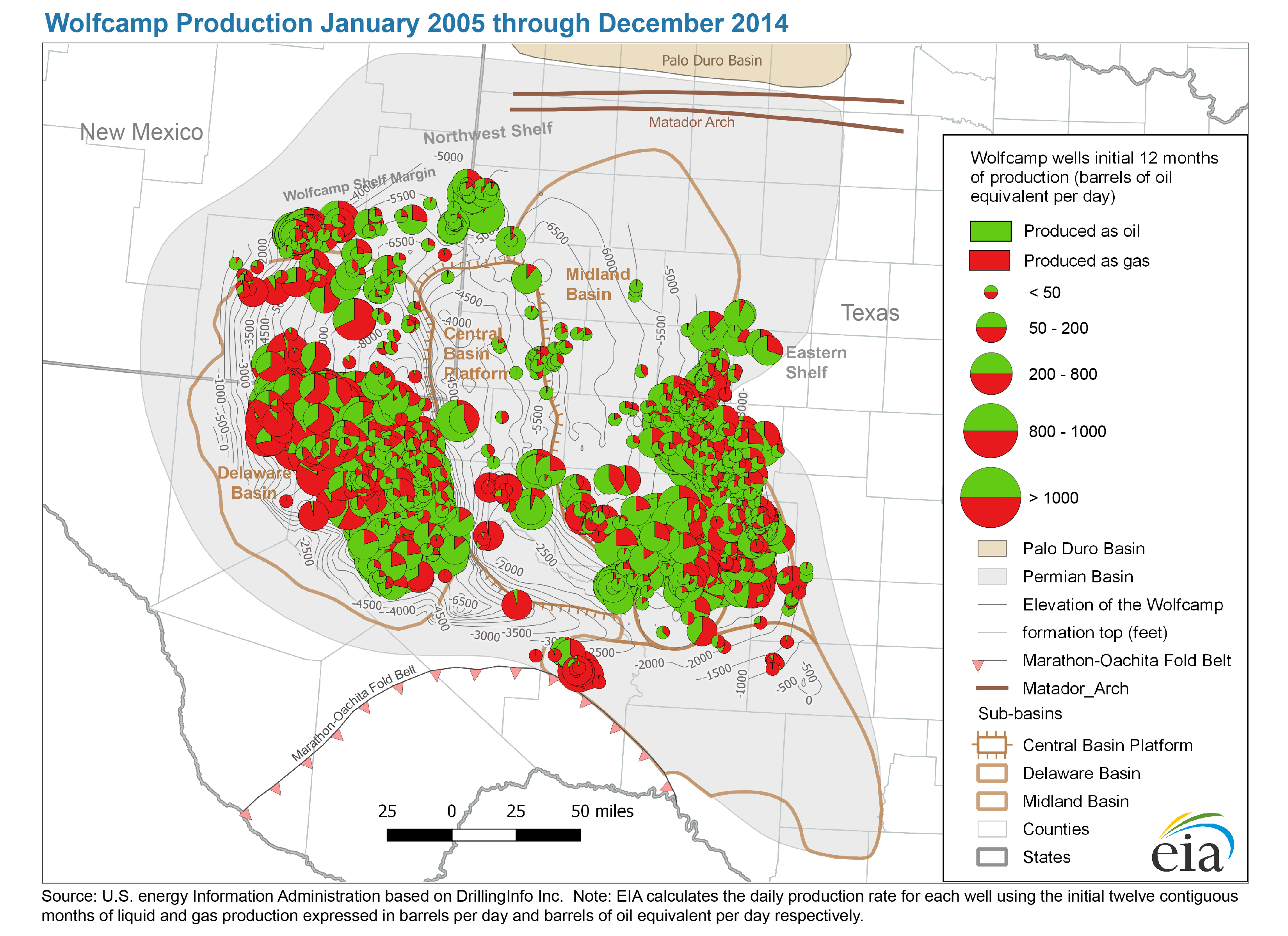
- Wolfcamp production January 2005 through December 2014
- Release date: August 7, 2018
- Available formats: PDF JPG
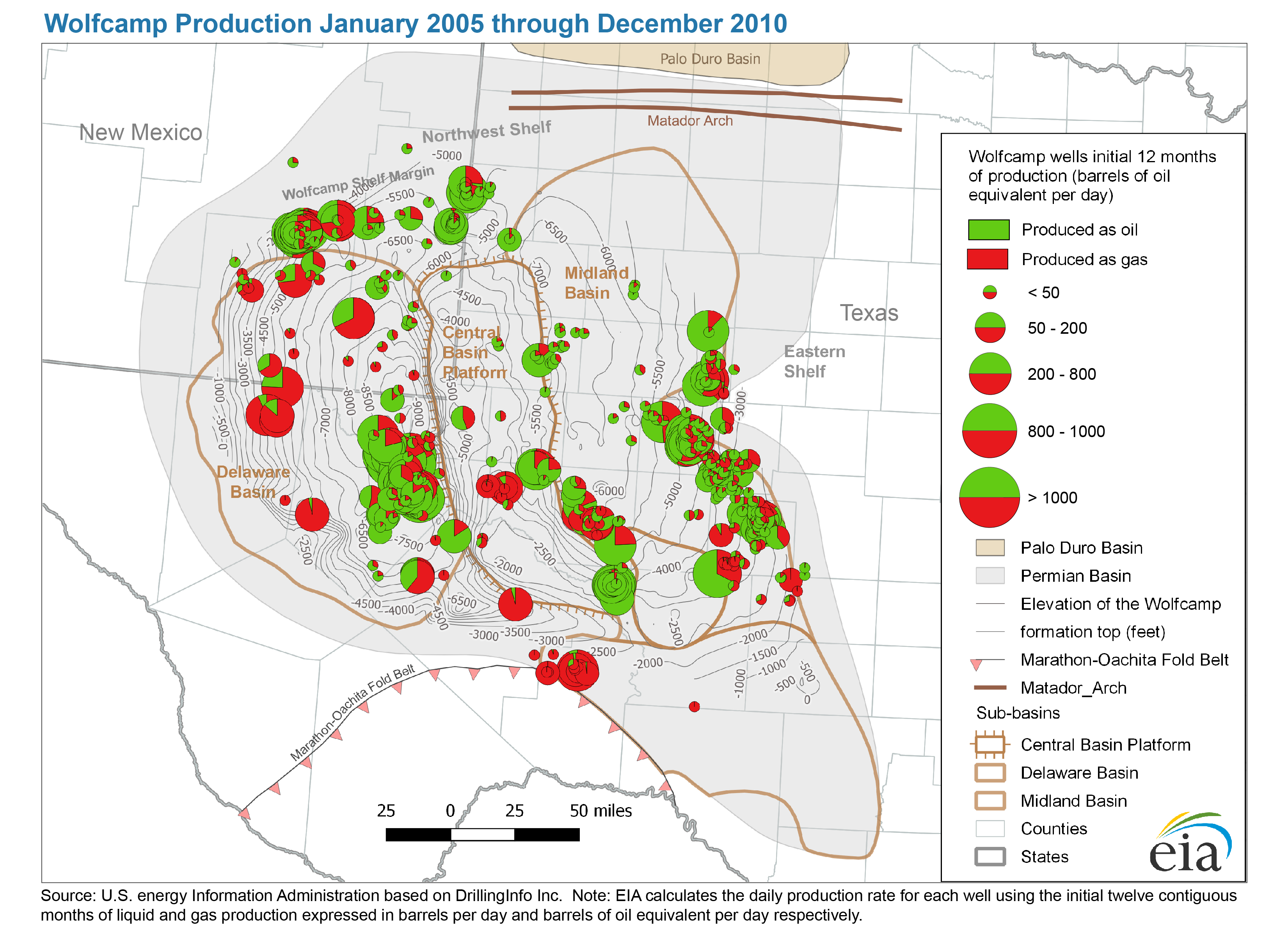
- Wolfcamp production January 2005 through December 2010
- Release date: August 7, 2018
- Available formats: PDF JPG
- Today in Energy article: The Wolfcamp play has been key to Permian Basin oil and natural gas production growth
- Map data
- Permian Basin: Wolfcamp formation elevation and isopachs
- Release date: December 21, 2017
- Available formats: Shapefile
- Permian Basin, Delaware Sub-Basin: Wolfcamp play boundary
- Release date: September 4, 2018
- Available formats: Shapefile
- Abo-Yeso, Glorieta-Yeso, and Spraberry play boundaries
- Release date: March 11, 2016
- Available formats: Shapefile
- Permian Basin: boundary, structure and tectonic features
- Release date: December 11, 2017
- Available formats: Shapefile
Delaware Subbasin (TX, NM)
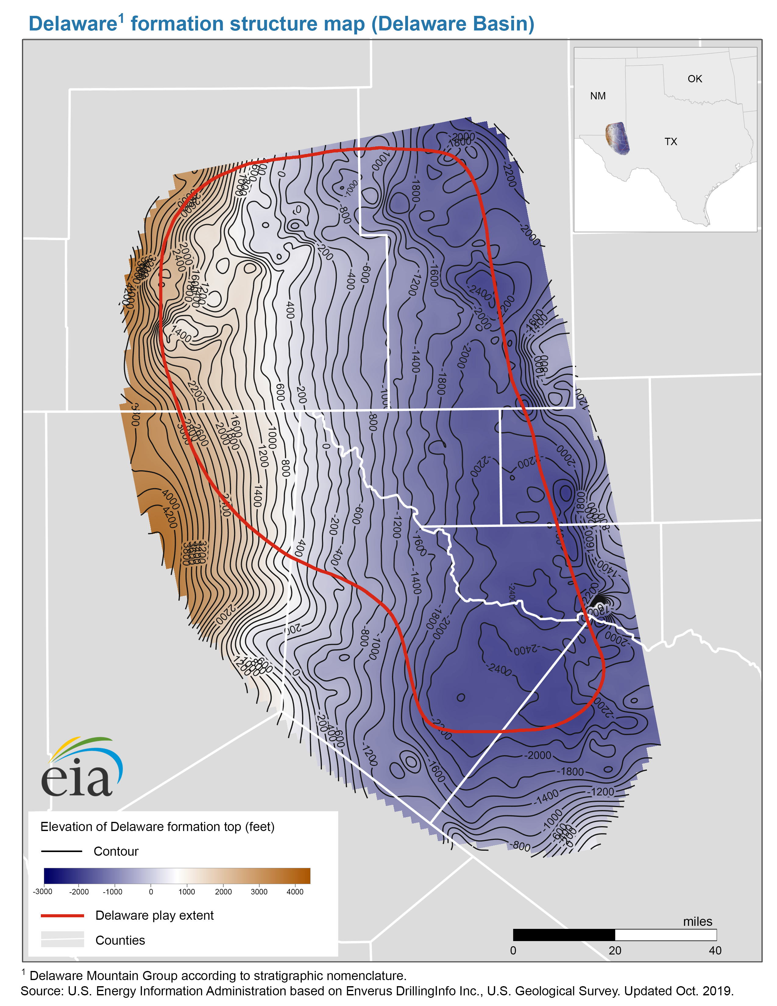
- Delaware formation structure map (Delaware Basin)
- Release date: October 28, 2019
- Available formats: PDF JPG
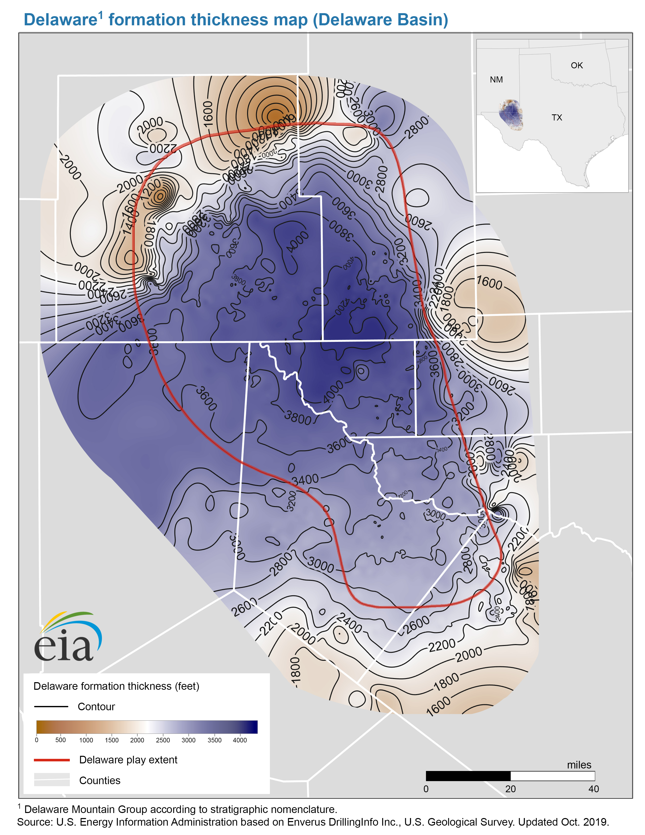
- Delaware formation thickness map (Delaware Basin)
- Release date: October 28, 2019
- Available formats: PDF JPG
- Map data
- Delaware play boundary
- Release date: October 8, 2019
- Available formats: Shapefile
- Delaware formation structure and isopachs
- Release date: October 29, 2019
- Available formats: Shapefile
- Bone Spring Play
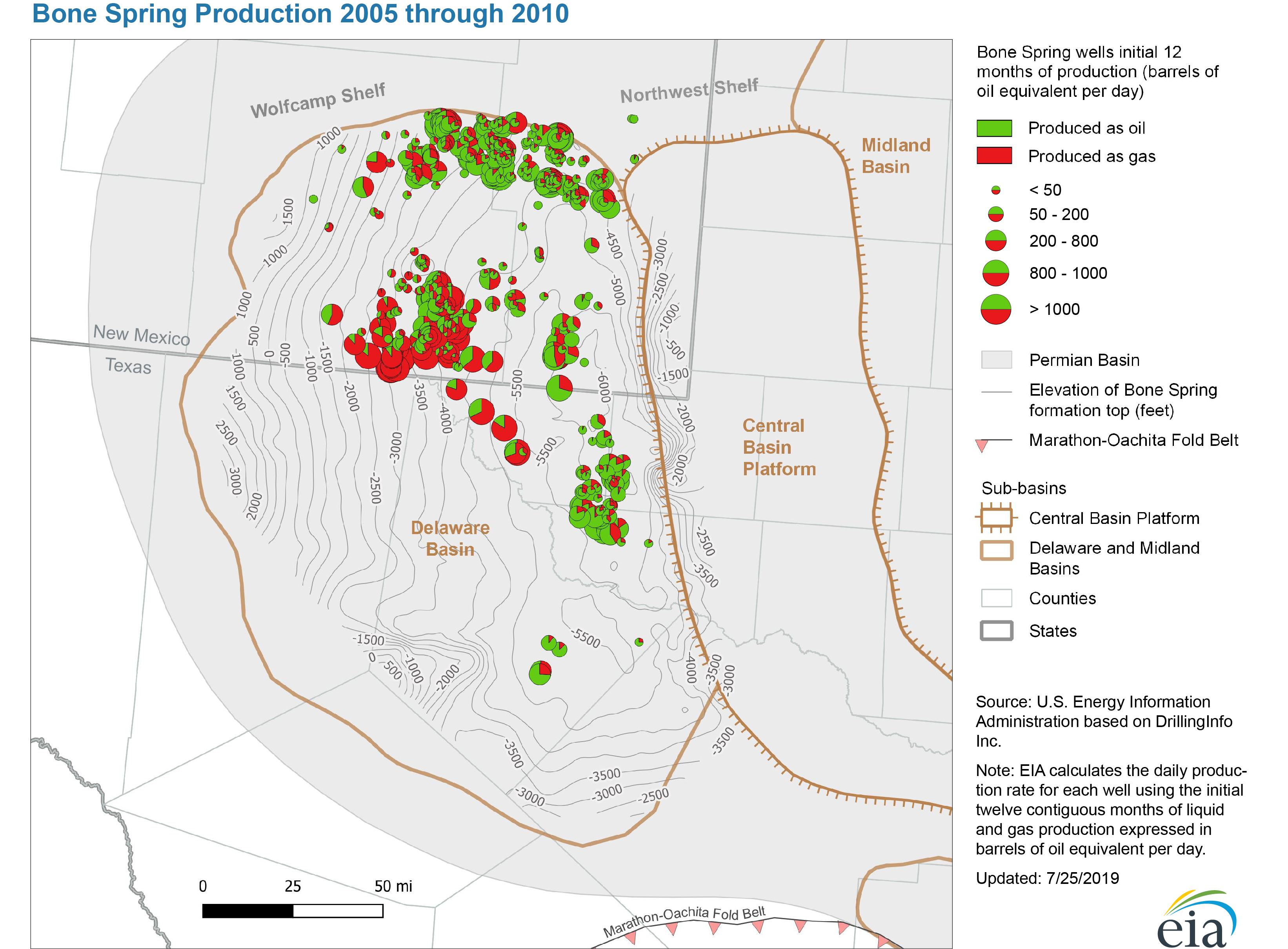
- Bone Spring Production 2005 through 2010
- Release date: July 25, 2019
- Available formats: PDF JPG
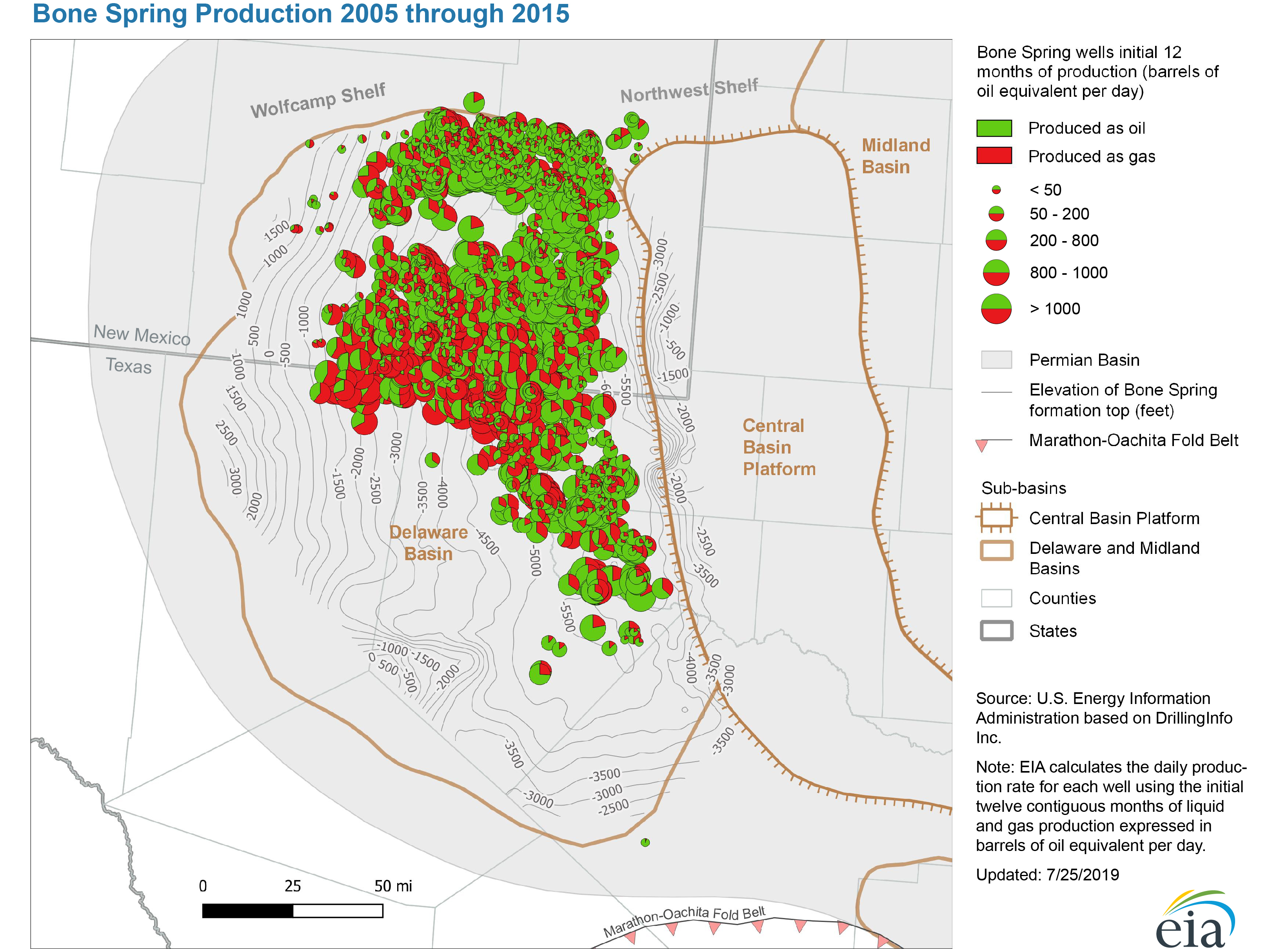
- Bone Spring Production 2005 through 2015
- Release date: July 25, 2019
- Available formats: PDF JPG
- Bone Spring Production 2005 through June 2019
- Release date: July 25, 2019
- Available formats: PDF JPG
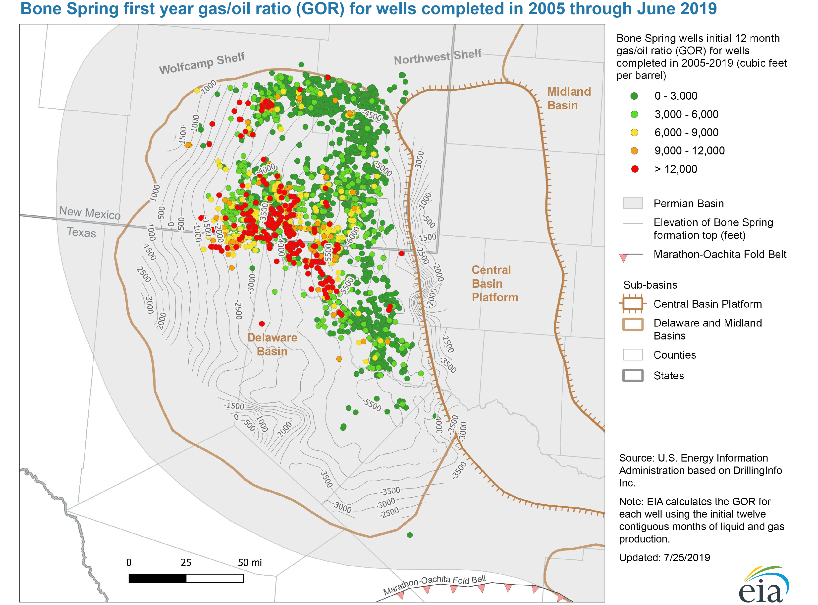
- Bone Spring first year gas/oil ratio (GOR) for wells completed 2005 through June 2019
- Release date: July 25, 2019
- Available formats: PDF JPG
- Structure map of the Avalon Bone Spring formation, Delaware Basin
- Release date: March 4, 2019
- Available formats: PDF JPG
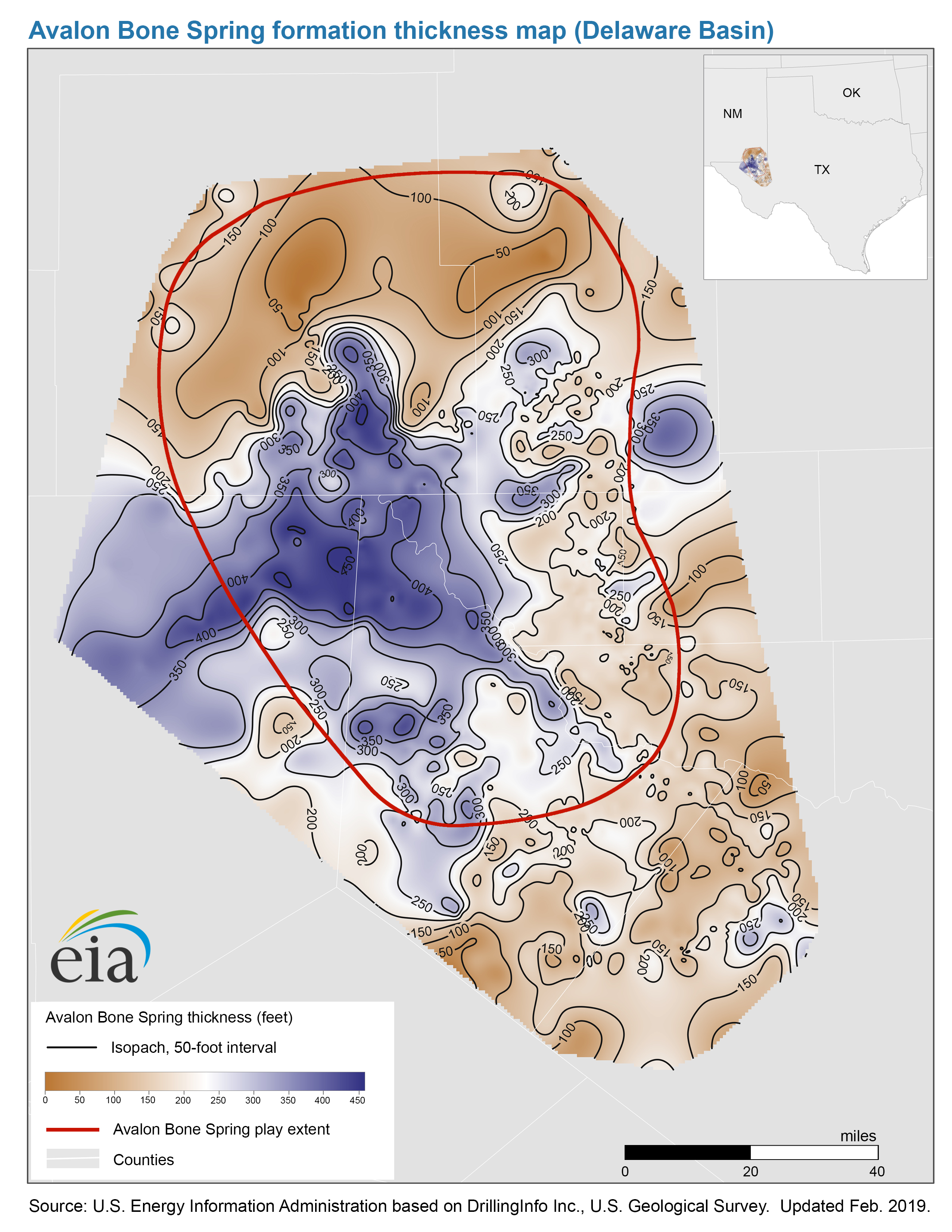
- Thickness map of the Avalon Bone Spring formation, Delaware Basin
- Release date: March 4, 2019
- Available formats: PDF JPG
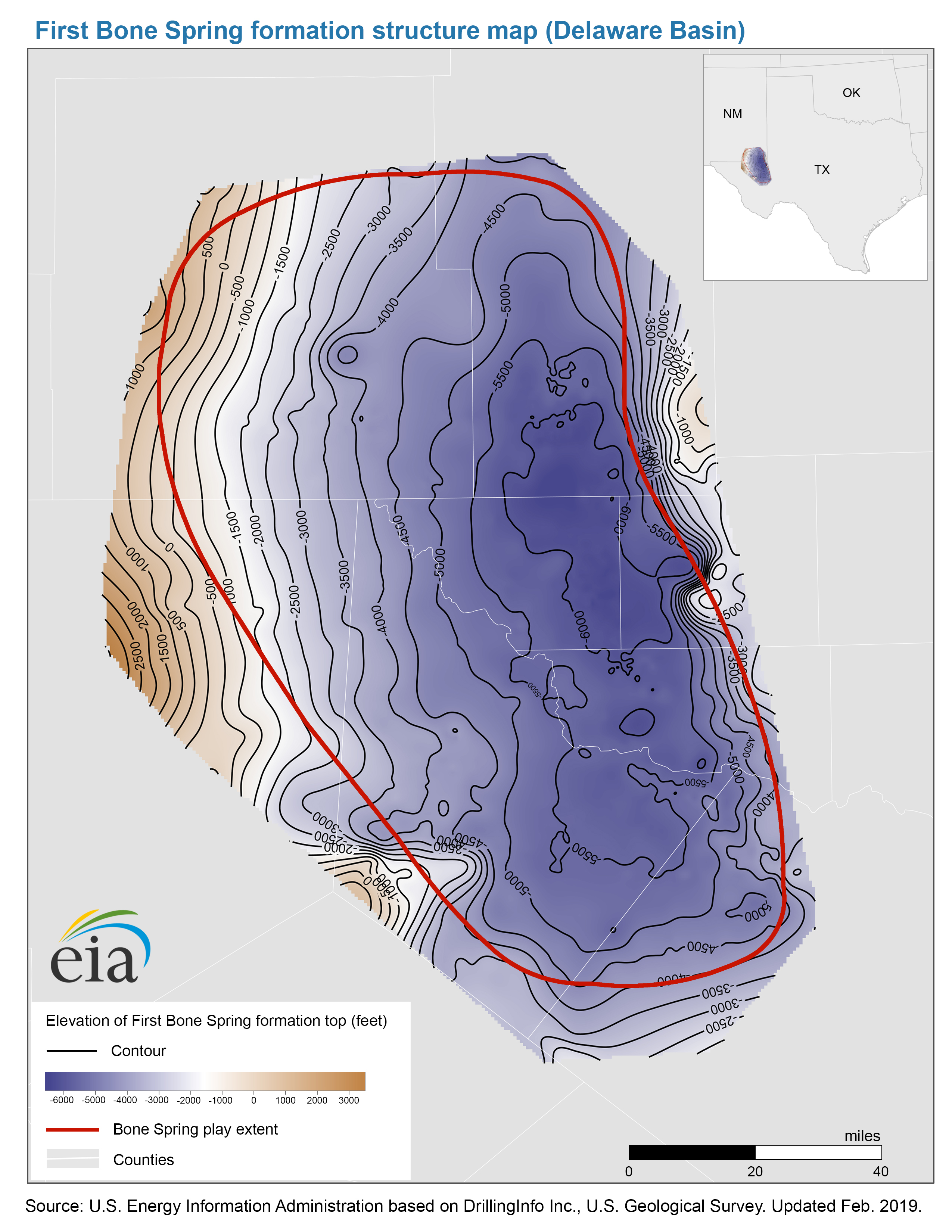
- Structure map of the First Bone Spring formation, Delaware Basin
- Release date: March 4, 2019
- Available formats: PDF JPG
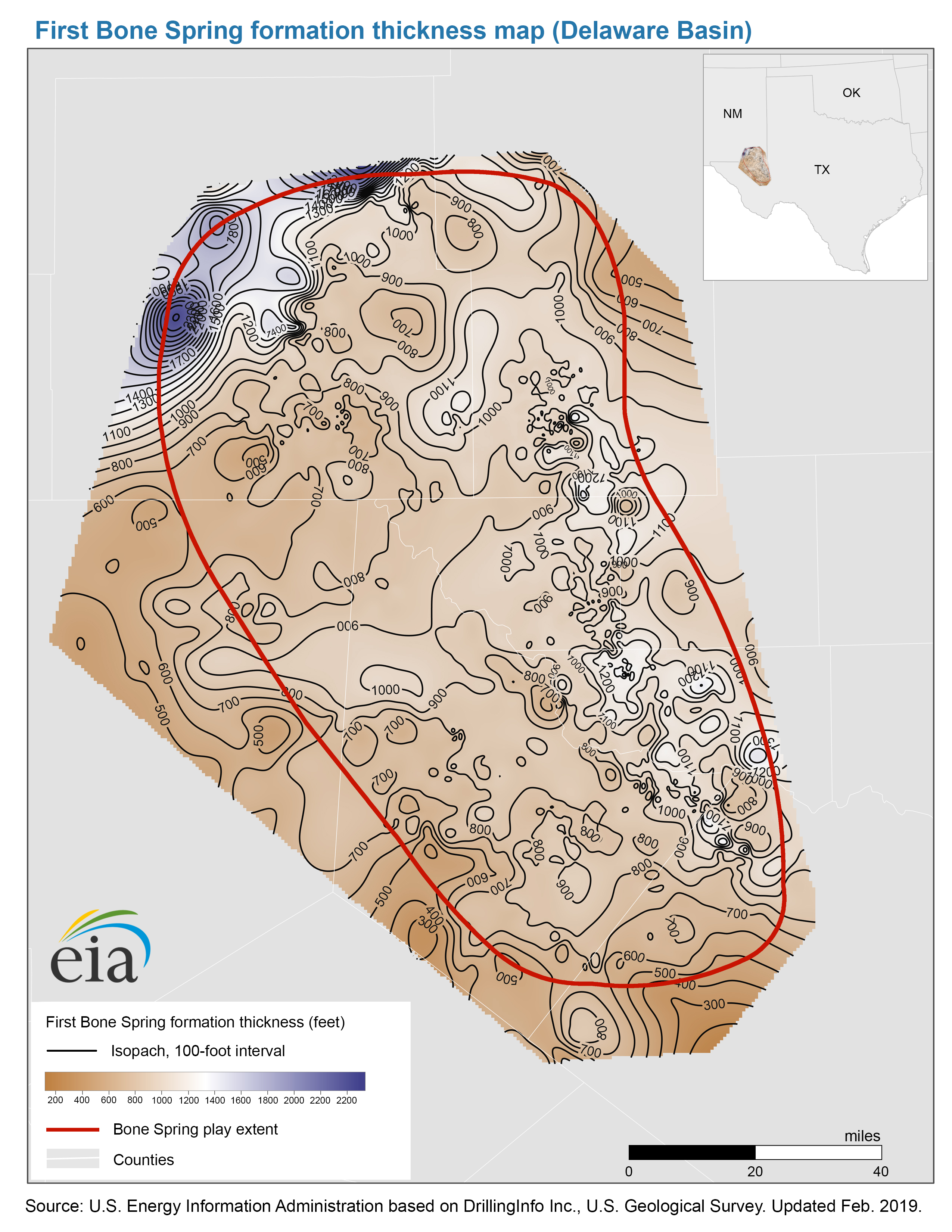
- Thickness map of the First Bone Spring formation, Delaware Basin
- Release date: March 4, 2019
- Available formats: PDF JPG
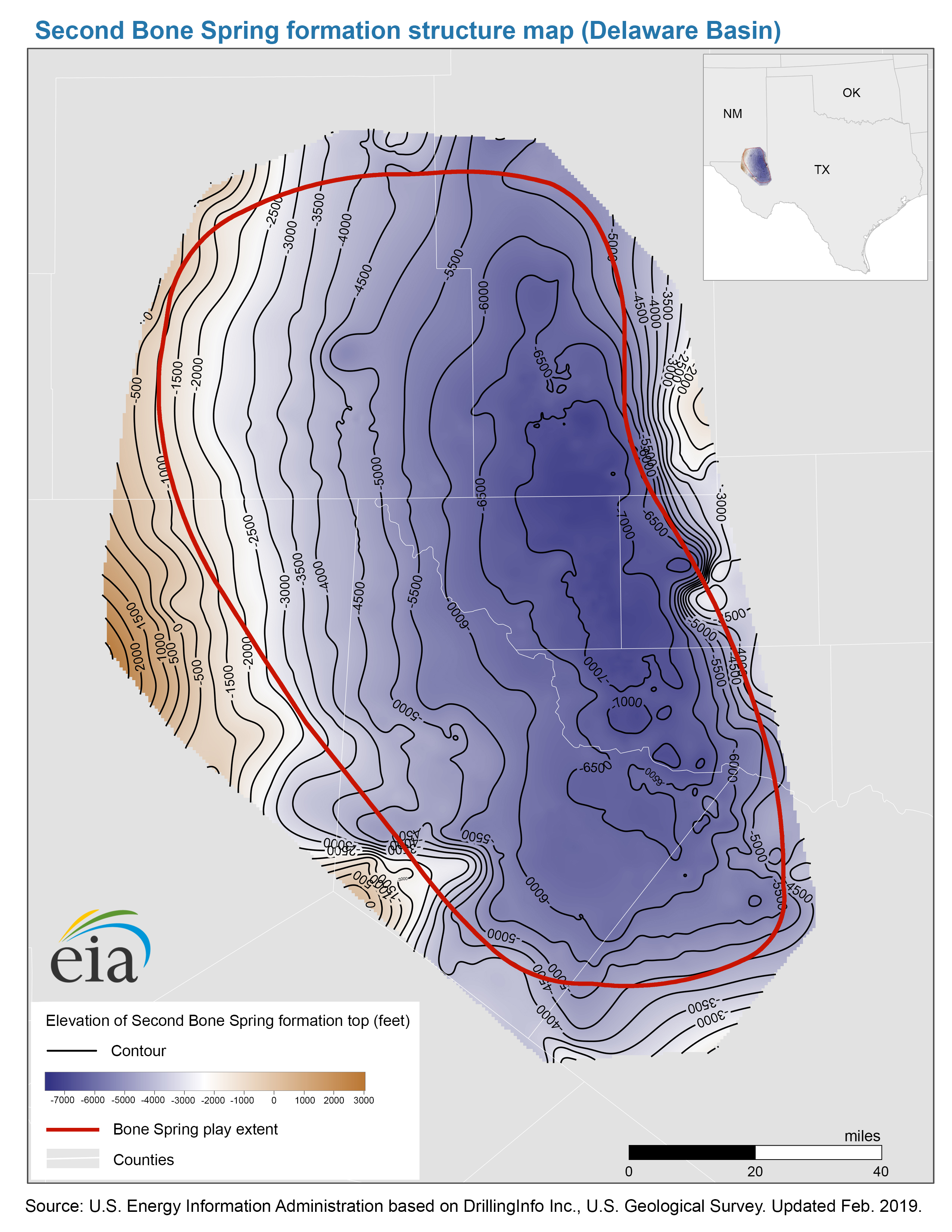
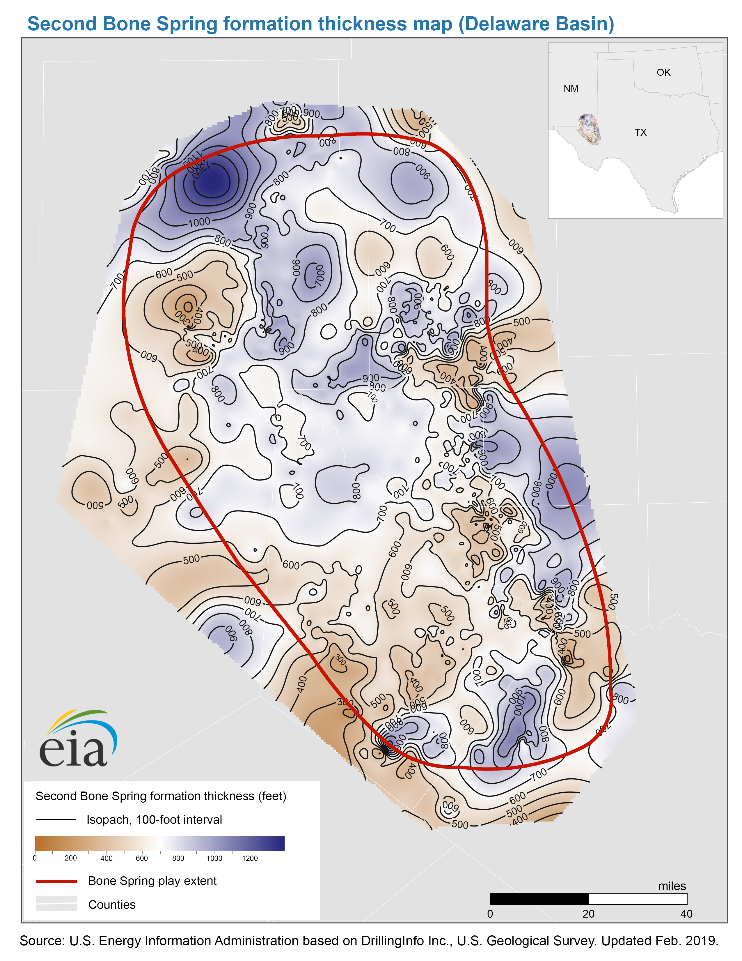
- Structure map of the Second Bone Spring formation, Delaware Basin
- Release date: March 4, 2019
- Available formats: PDF JPG
- Thickness map of the Second Bone Spring formation, Delaware Basin
- Release date: March 4, 2019
- Available formats: PDF JPG
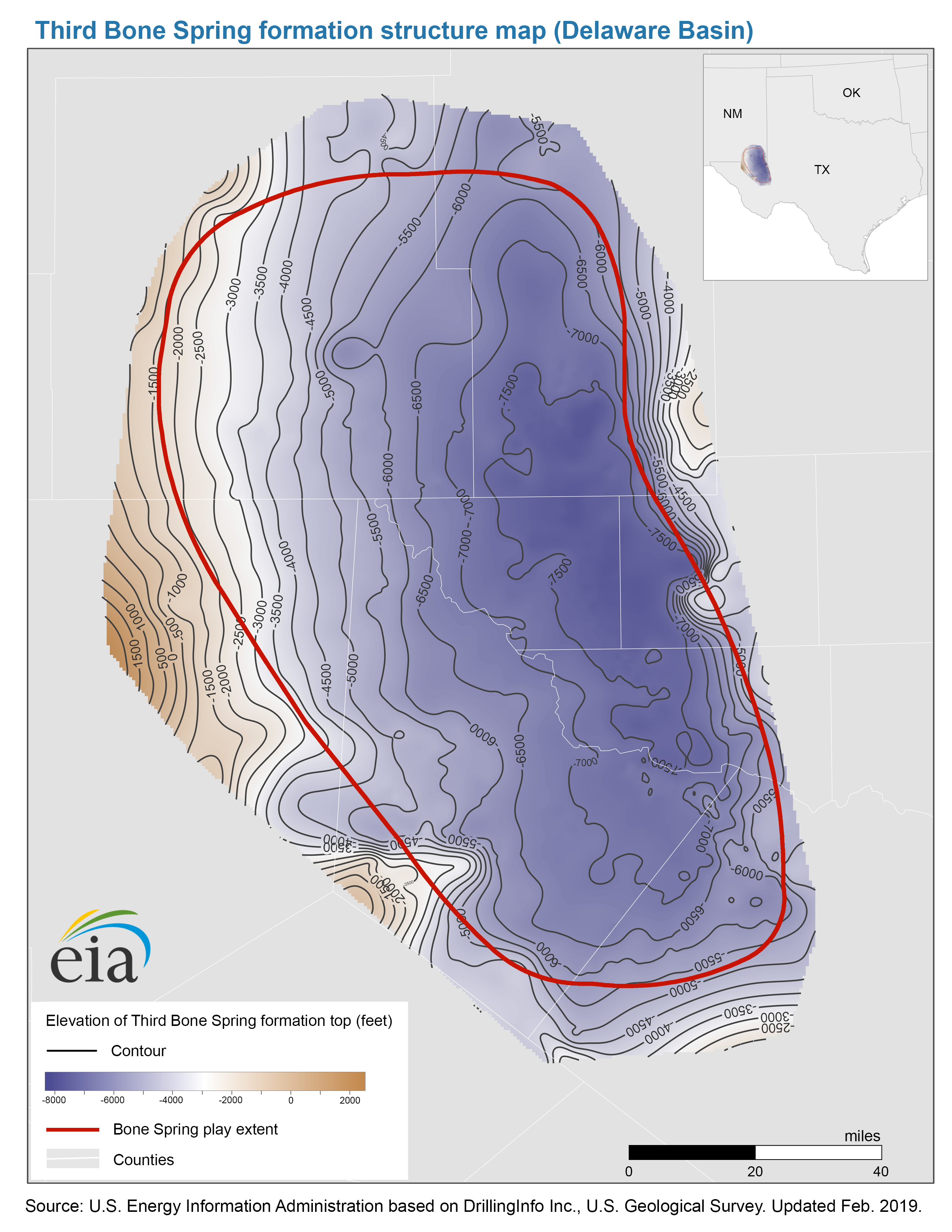
- Structure map of the Third Bone Spring formation, Delaware Basin
- Release date: March 4, 2019
- Available formats: PDF JPG
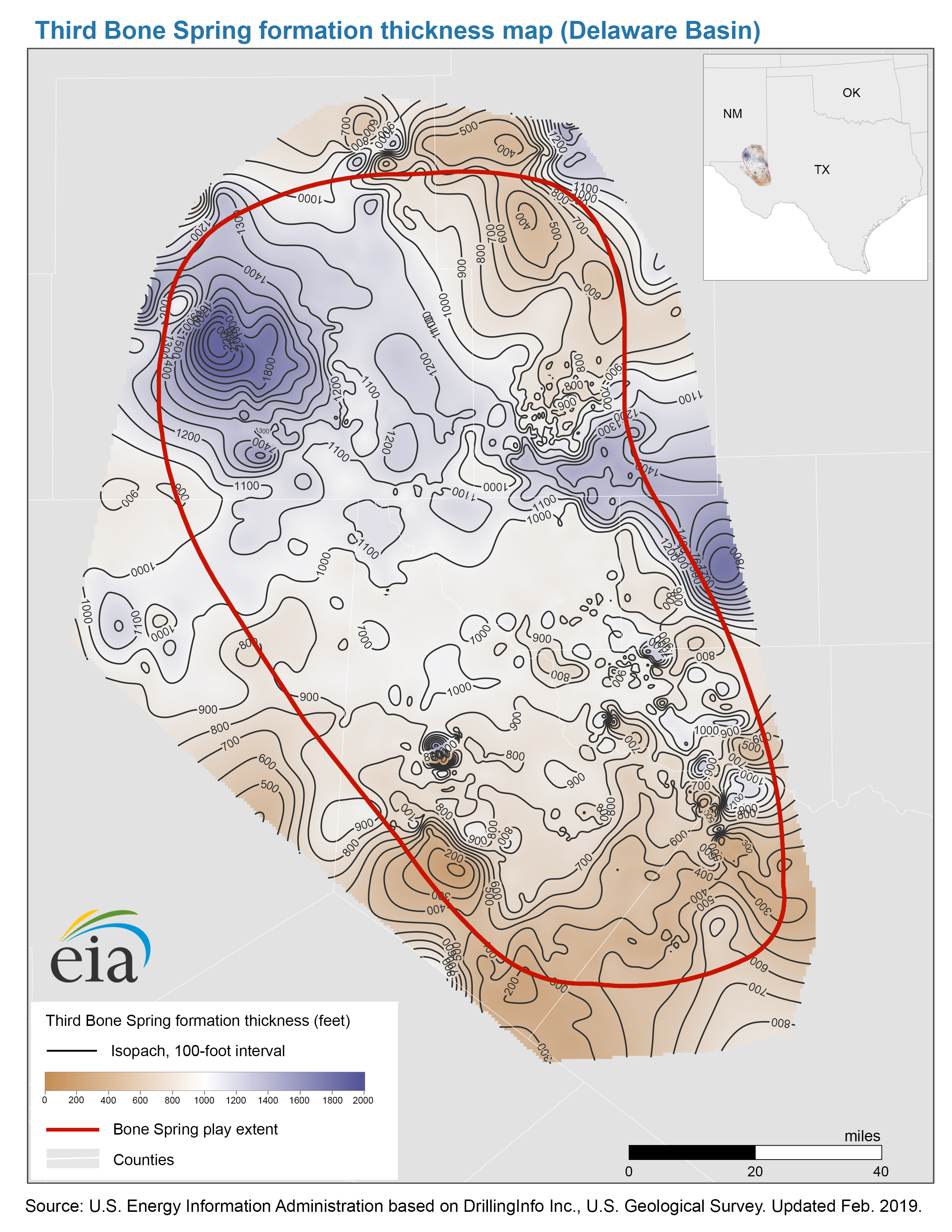
- Thickness map of the Third Bone Spring formation, Delaware Basin
- Release date: March 4, 2019
- Available formats: PDF JPG
- Map data
- Bone Spring formation benches structure and isopachs
- Release date: March 26, 2019
- Available formats: Shapefile
- Bone Spring and Avalon Bone Spring play extents
- Release date: March 26, 2019
- Available formats: Shapefile
- Wolfcamp Play
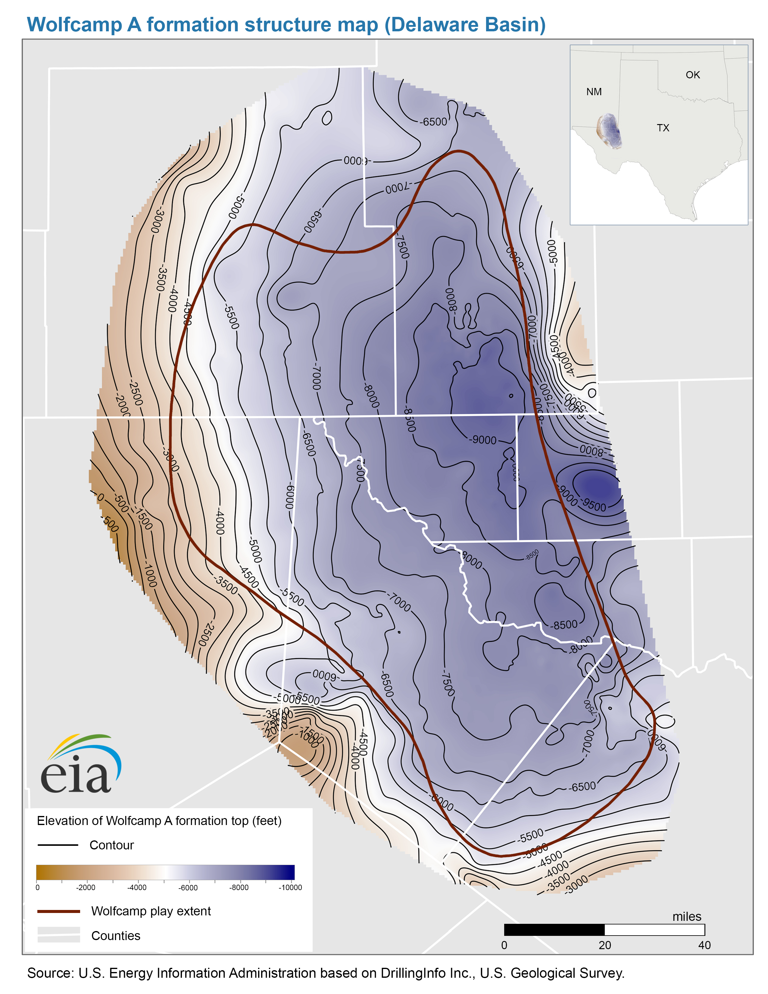
- Structure map of the Wolfcamp A formation, Delaware Basin
- Release date: August 24, 2018
- Available formats: PDF JPG
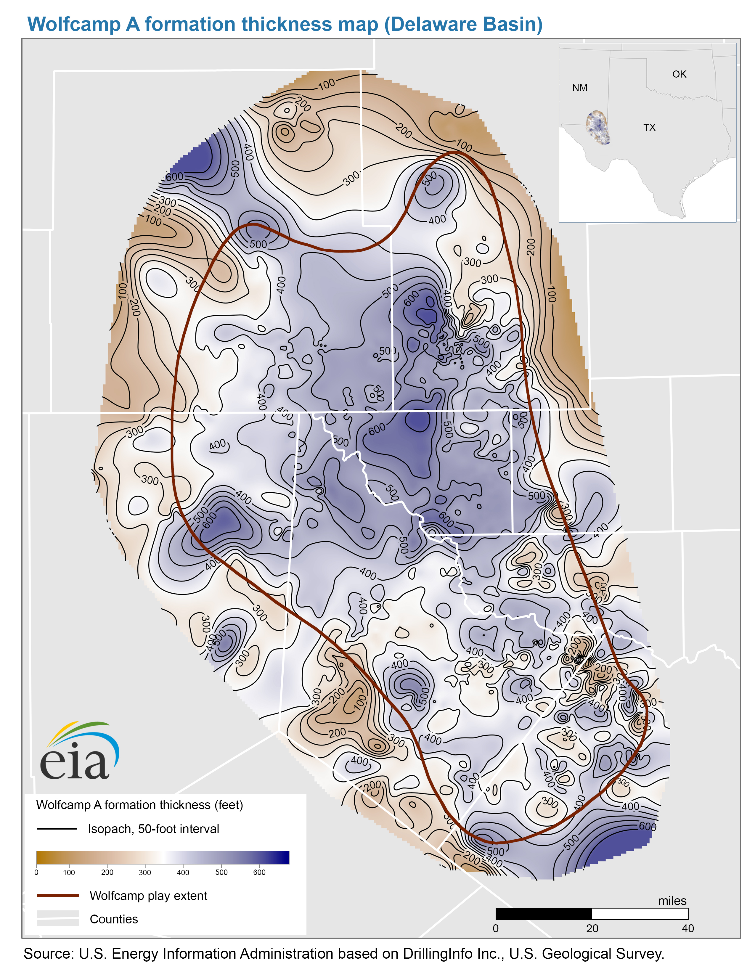
- Thickness map of the Wolfcamp A formation, Delaware Basin
- Release date: August 24, 2018
- Available formats: PDF JPG
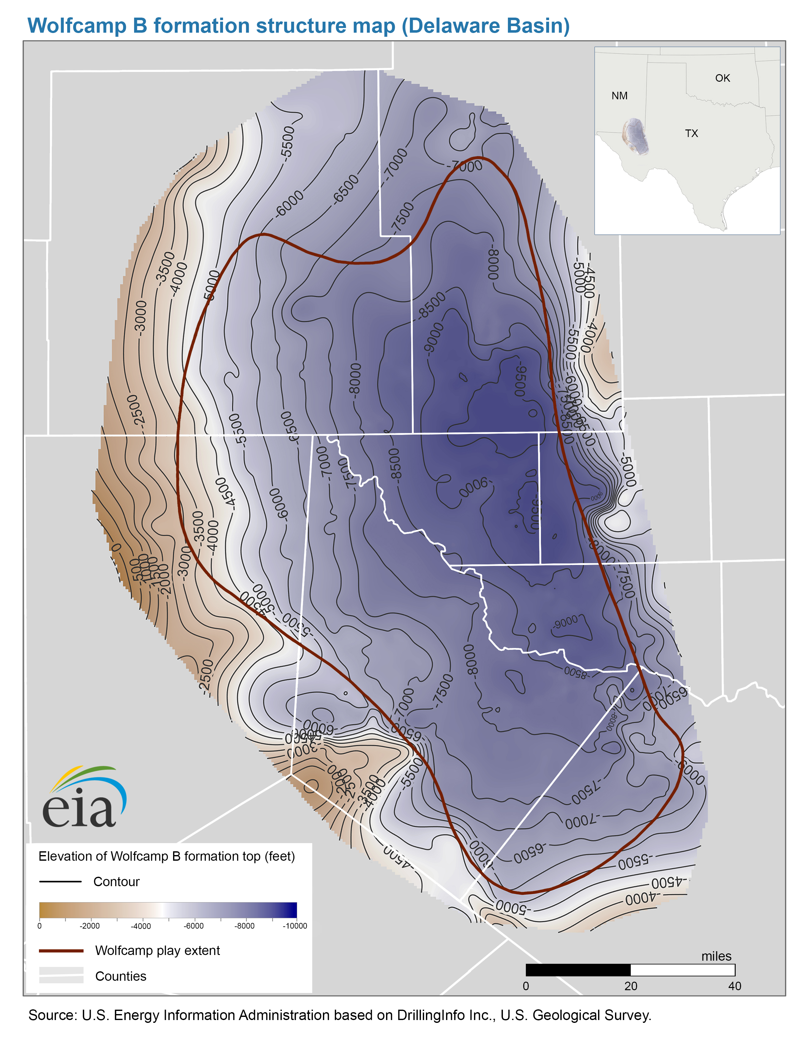
- Structure map of the Wolfcamp B formation, Delaware Basin
- Release date: November 26, 2018
- Available formats: PDF JPG
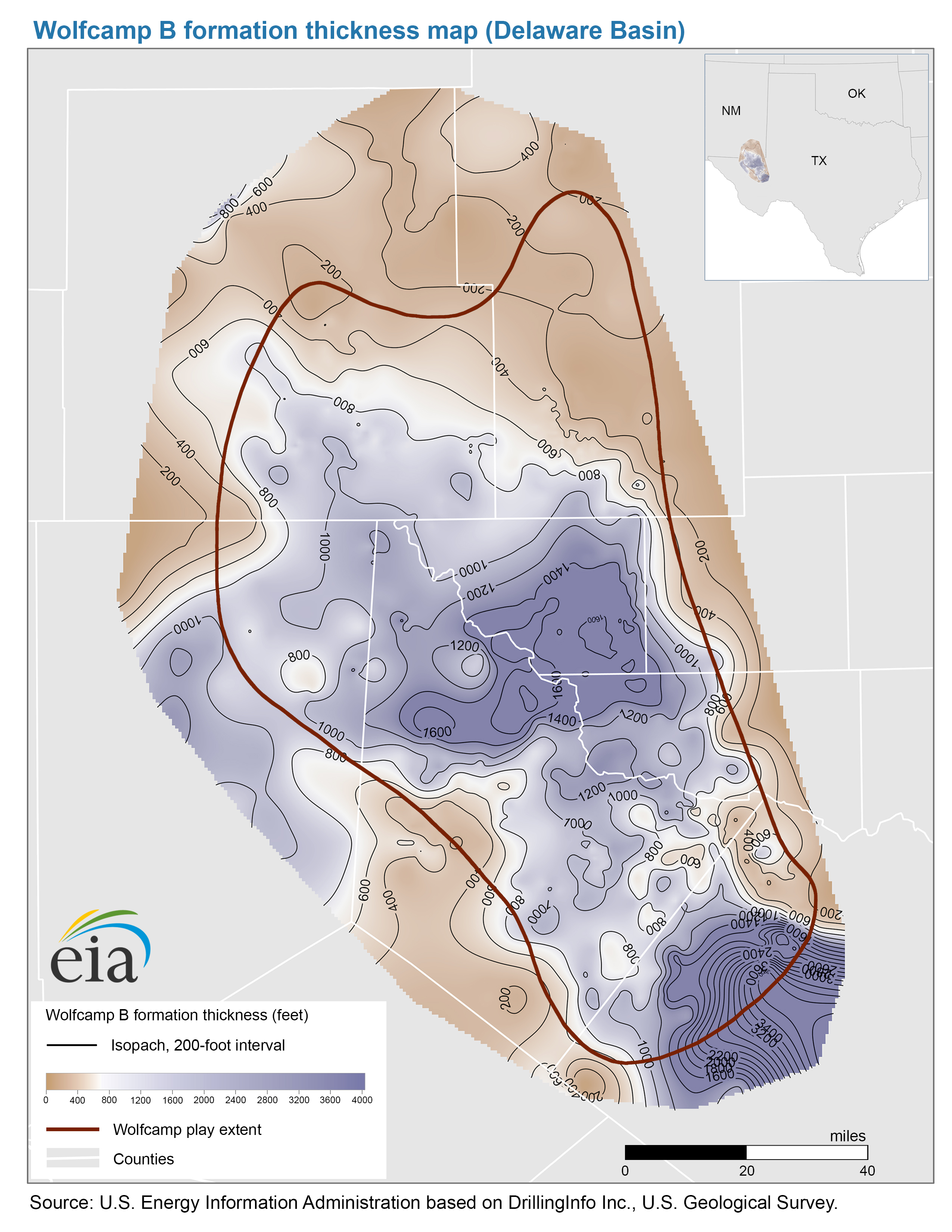
- Thickness map of the Wolfcamp B formation, Delaware Basin
- Release date: November 26, 2018
- Available formats: PDF JPG
- Map data
- Wolfcamp A formation structure and isopachs, Delaware Basin
- Release date: September 4, 2018
- Available formats: Shapefile
- Wolfcamp B formation structure and isopachs, Delaware Basin
- Release date: November 29, 2018
- Available formats: Shapefile
Midland Subbasin (TX)
- Spraberry Play
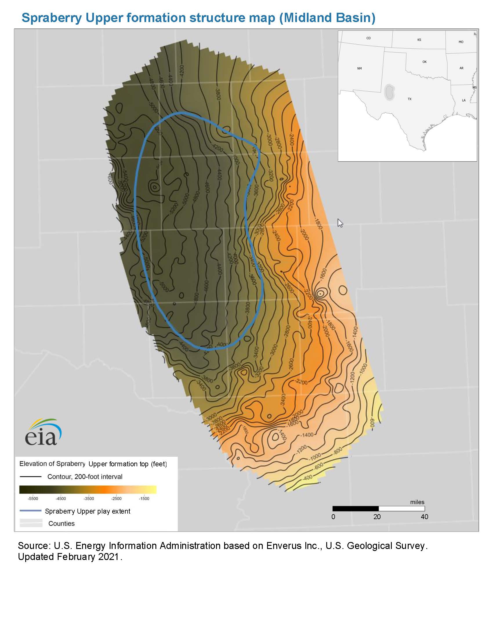
- Structure map of the Spraberry Upper formation, Midland Basin
- Release date: December 13, 2021
- Available formats: PDF JPG
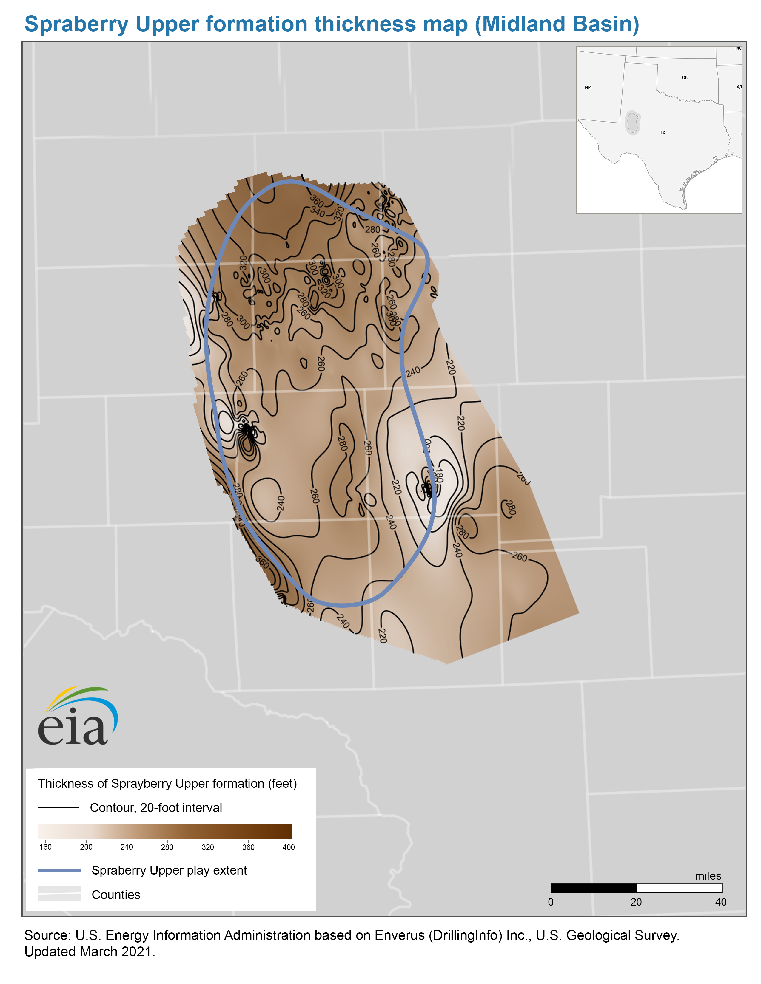
- Thickness map of the Spraberry Upper formation, Midland Basin
- Release date: December 13, 2021
- Available formats: PDF JPG
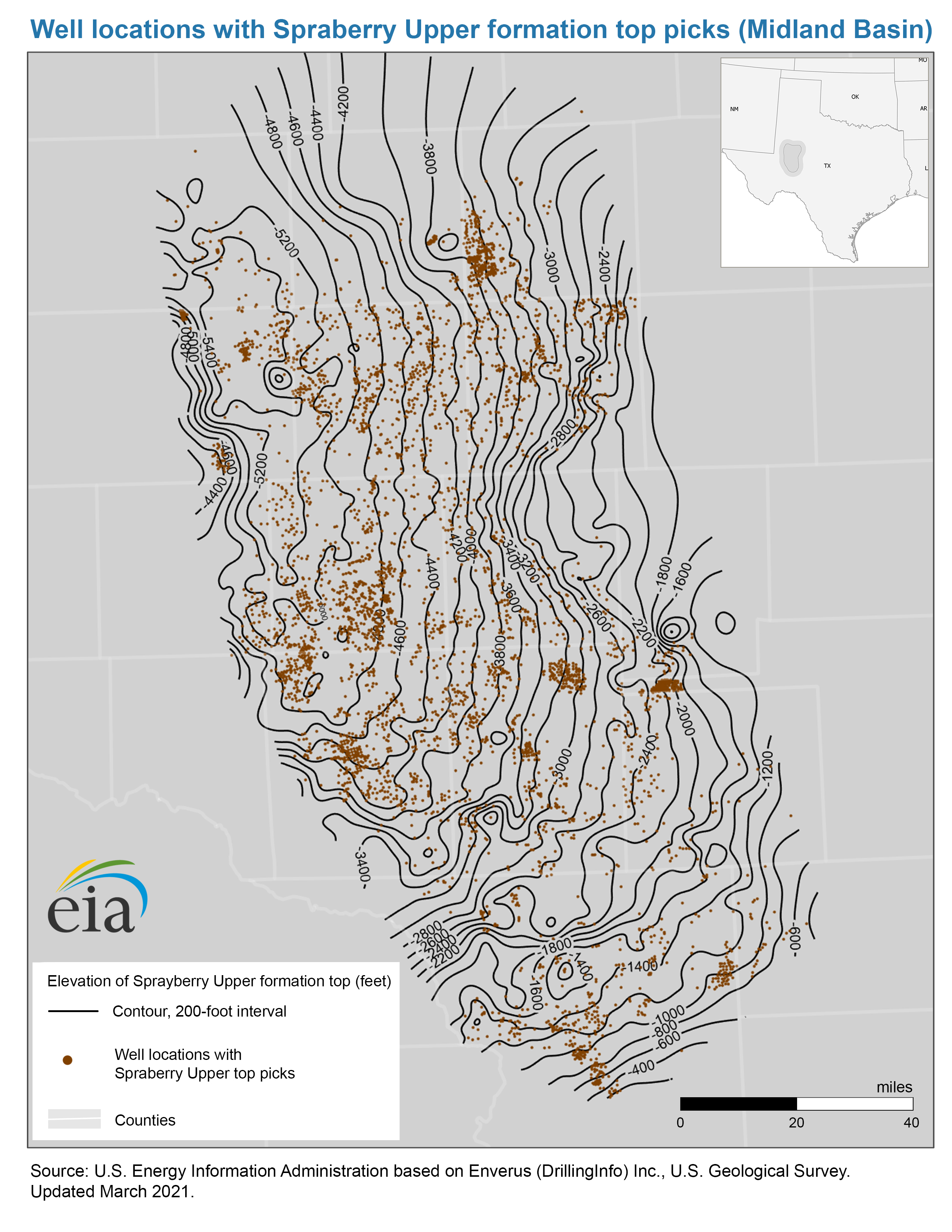
- Well locations with Spraberry Upper top picks map, Midland Basin
- Release date: December 13, 2021
- Available formats: PDF JPG
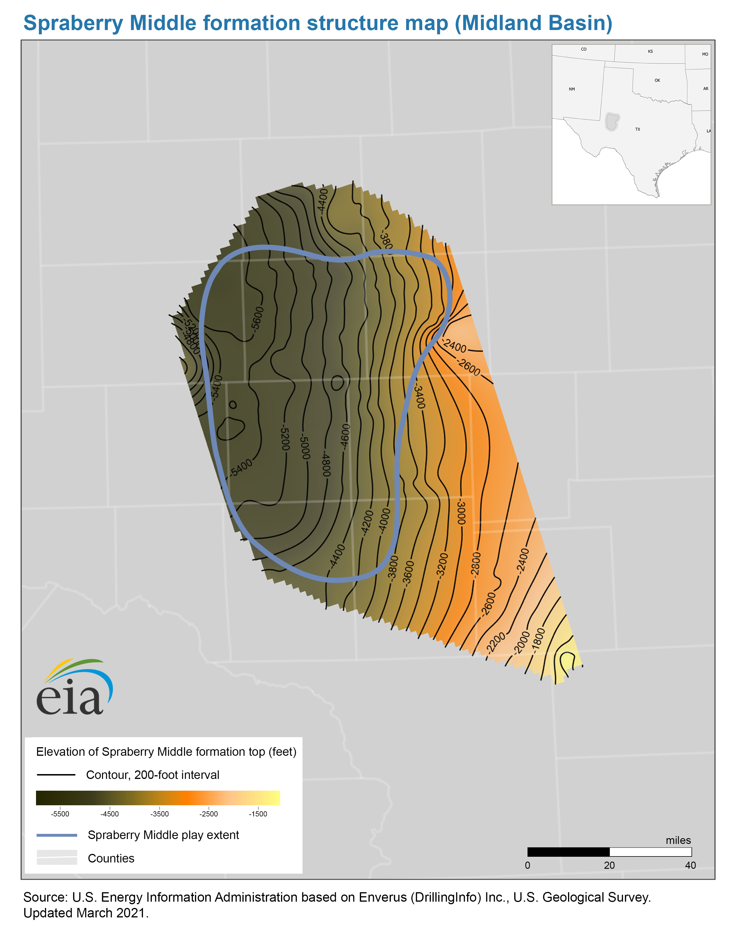
- Structure map of the Spraberry Middle formation, Midland Basin
- Release date: December 13, 2021
- Available formats: PDF JPG
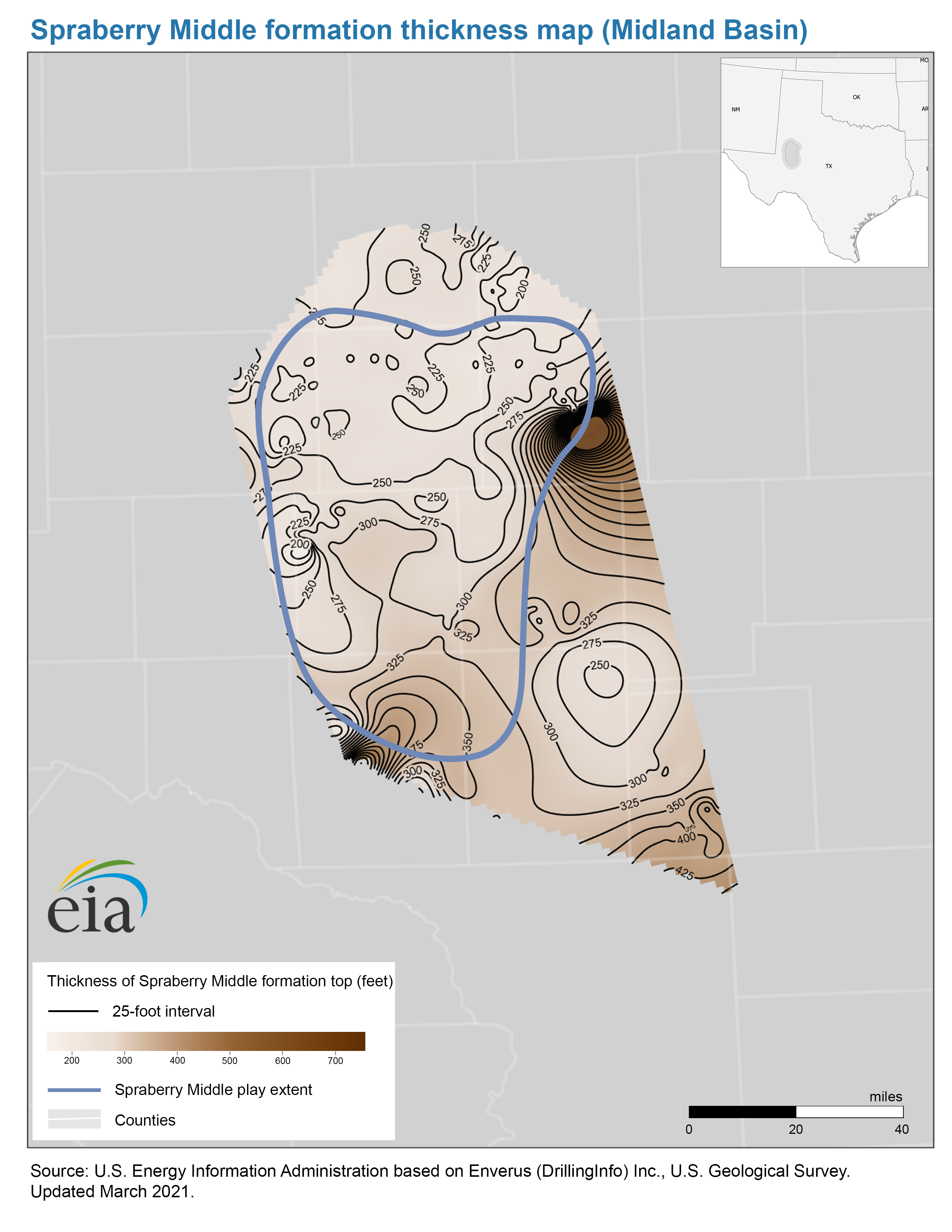
- Thickness map of the Spraberry Middle formation, Midland Basin
- Release date: December 13, 2021
- Available formats: PDF JPG
- Well locations with Spraberry Middle top picks map, Midland Basin
- Release date: December 13, 2021
- Available formats: PDF JPG
- Structure map of the Spraberry Lower formation, Midland Basin
- Release date: February 13, 2020
- Available formats: PDF JPG
- Thickness map of the Spraberry Lower formation, Midland Basin
- Release date: February 13, 2020
- Available formats: PDF JPG
- Well locations with Spraberry Lower top picks map, Midland Basin
- Release date: February 13, 2020
- Available formats: PDF JPG
- Map data
- Spraberry Upper play boundaries, formation structure and isopachs
- Release date: December 13, 2021
- Available formats: Shapefile
- Spraberry Middle play boundaries, formation structure and isopachs
- Release date: December 13, 2021
- Available formats: Shapefile
- Spraberry Lower formation structure and isopachs, Midland Basin
- Release date: March 5, 2021
- Available formats: Shapefile
- Spraberry Lower play boundaries, Midland Basin
- Release date: March 5, 2021
- Available formats: Shapefile
- Wolfcamp Play
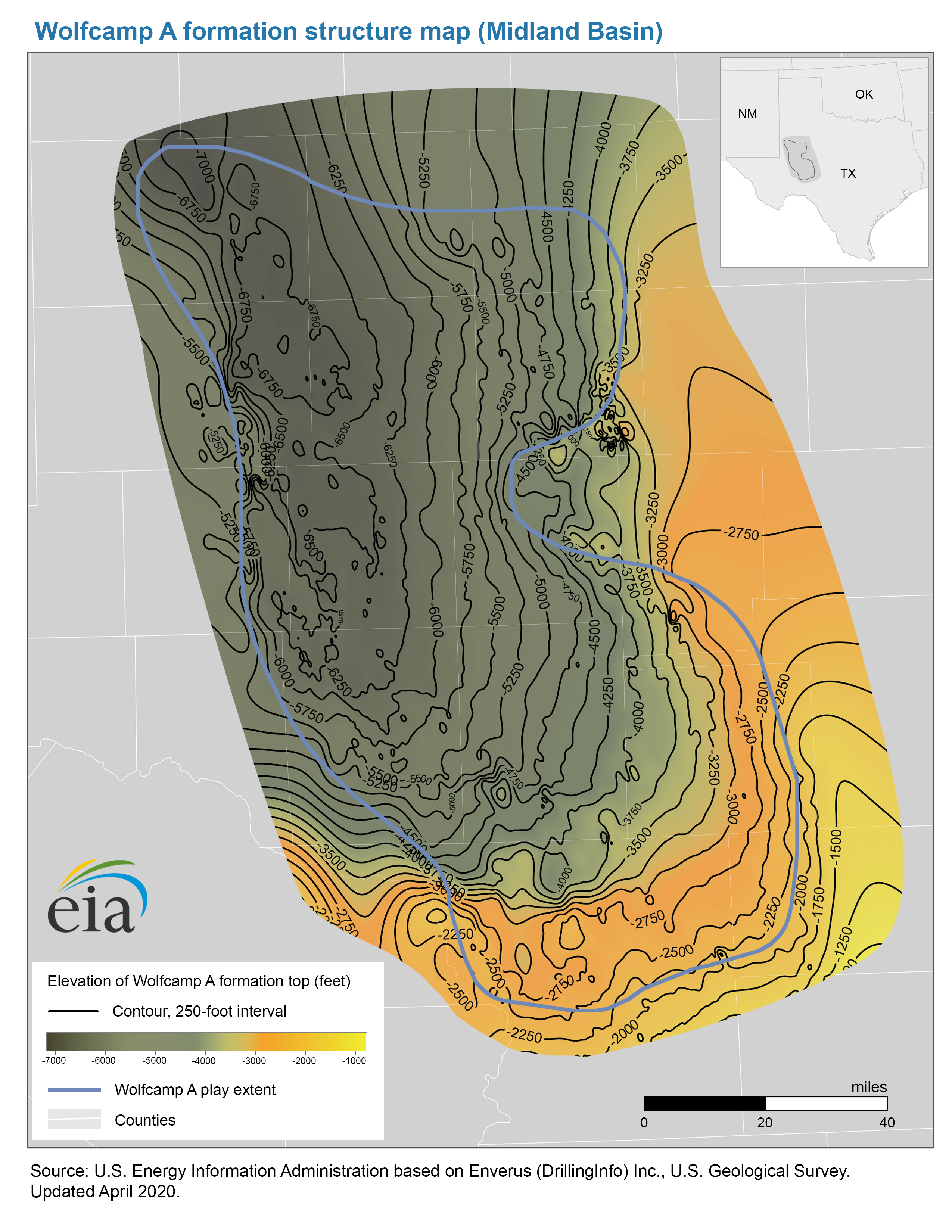
- Structure map of the Wolfcamp A formation, Midland Basin
- Release date: April 23, 2020
- Available formats: PDF JPG
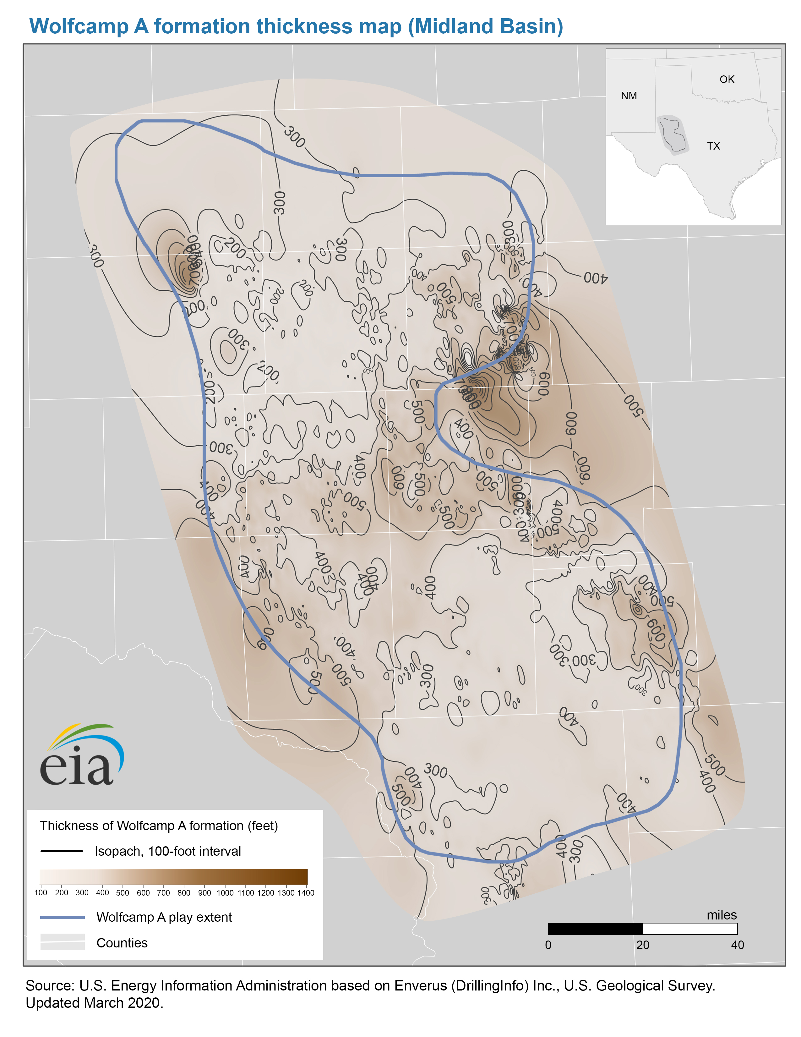
- Thickness map of the Wolfcamp A formation, Midland Basin
- Release date: April 23, 2020
- Available formats: PDF JPG
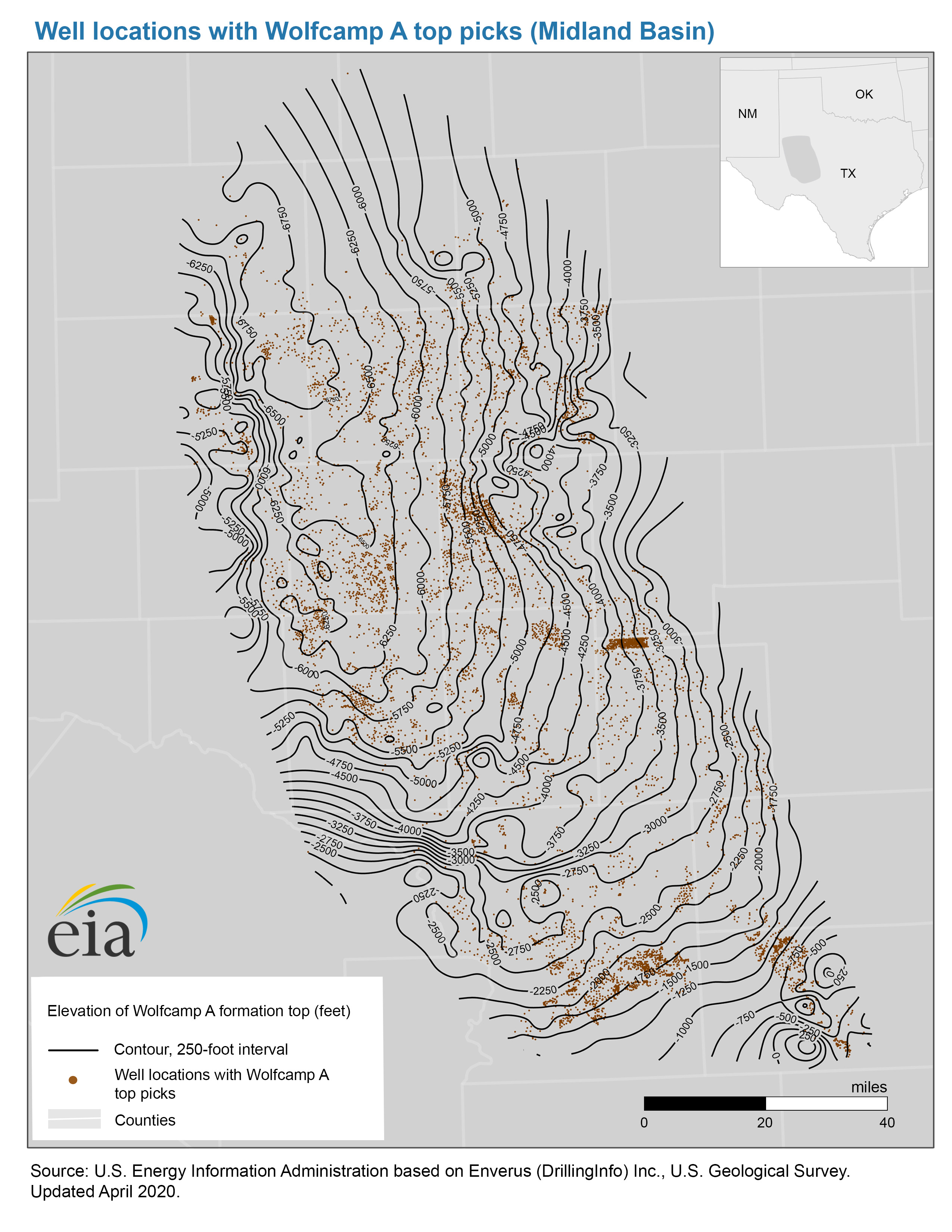
- Well locations with Wolfcamp A top picks map, Midland Basin
- Release date: October 8, 2020
- Available formats: PDF JPG
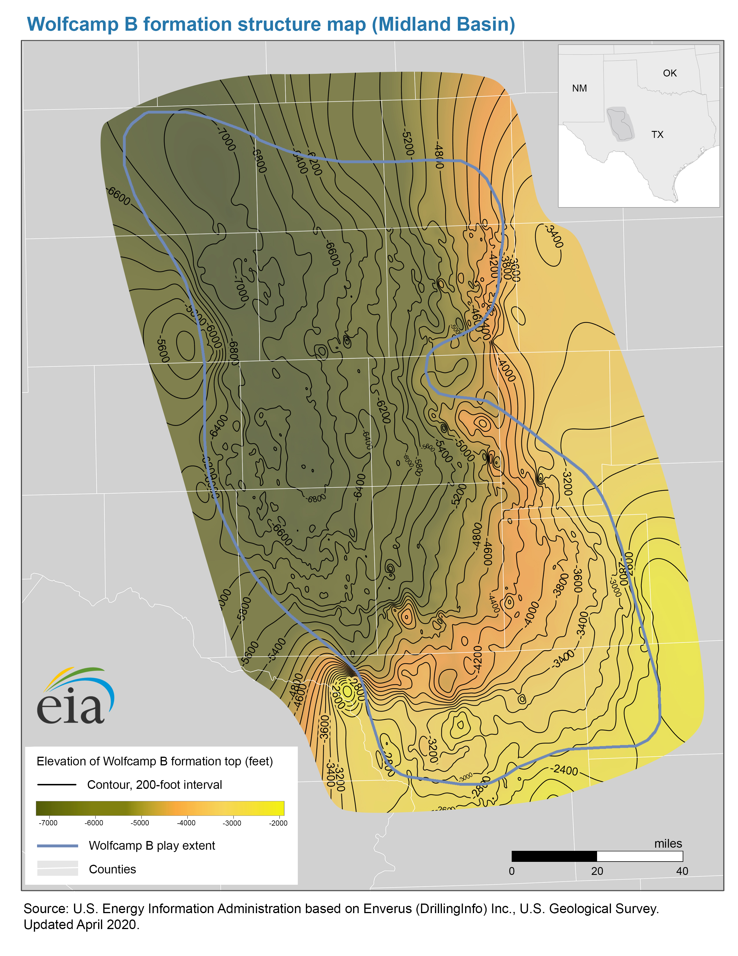
- Structure map of the Wolfcamp B formation, Midland Basin
- Release date: April 23, 2020
- Available formats: PDF JPG
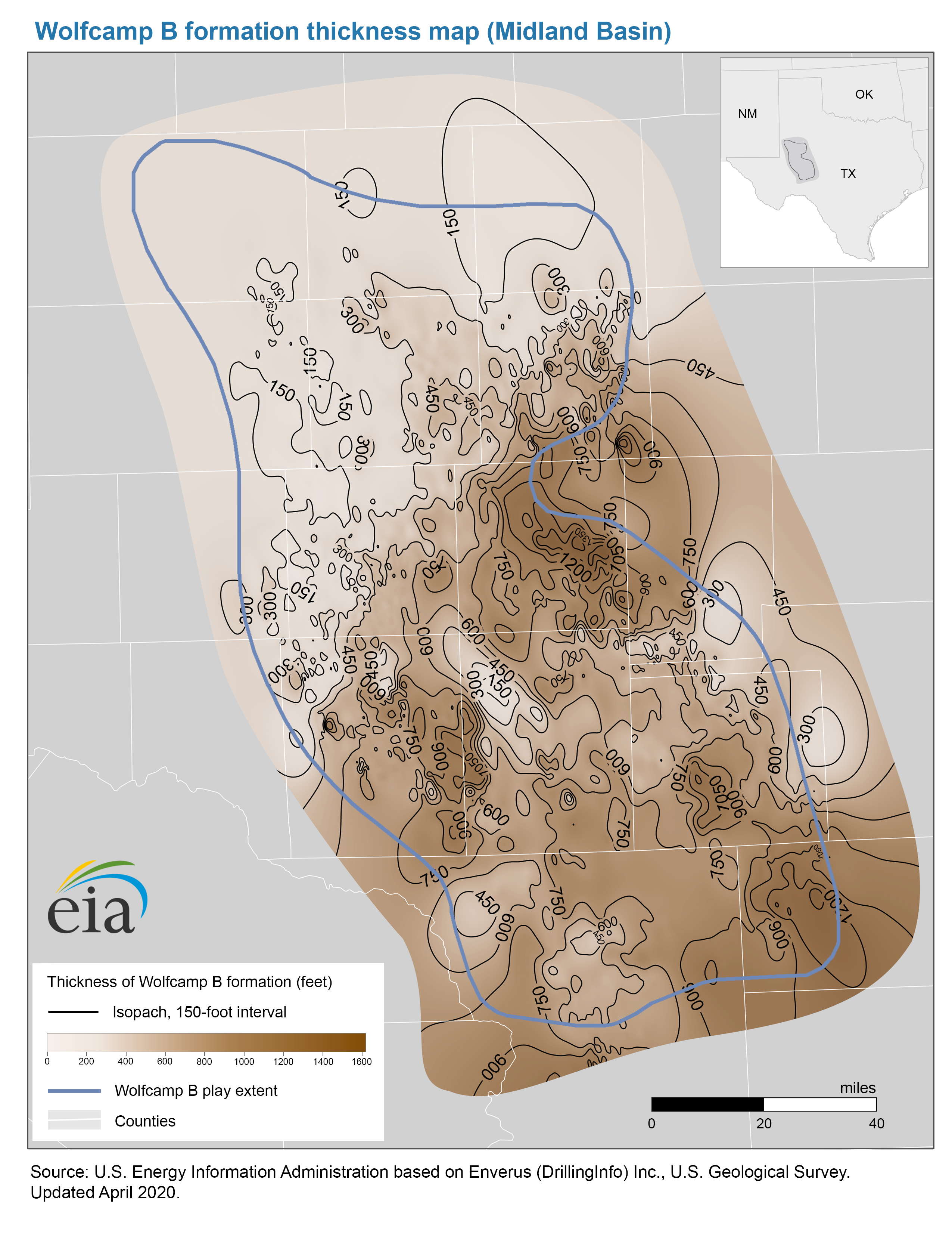
- Thickness map of the Wolfcamp B formation, Midland Basin
- Release date: April 23, 2020
- Available formats: PDF JPG
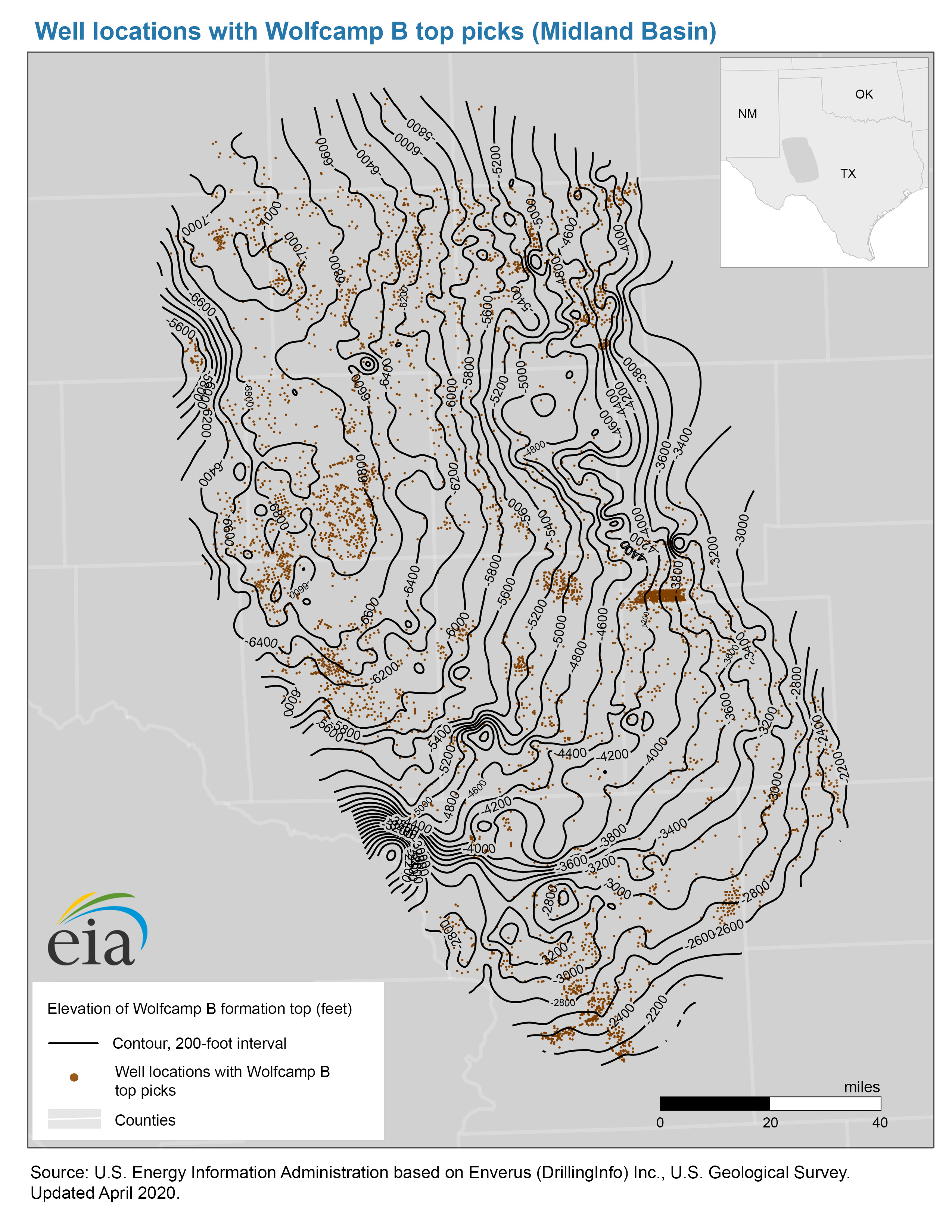
- Well locations with Wolfcamp B top picks map, Midland Basin
- Release date: October 8, 2020
- Available formats: PDF JPG
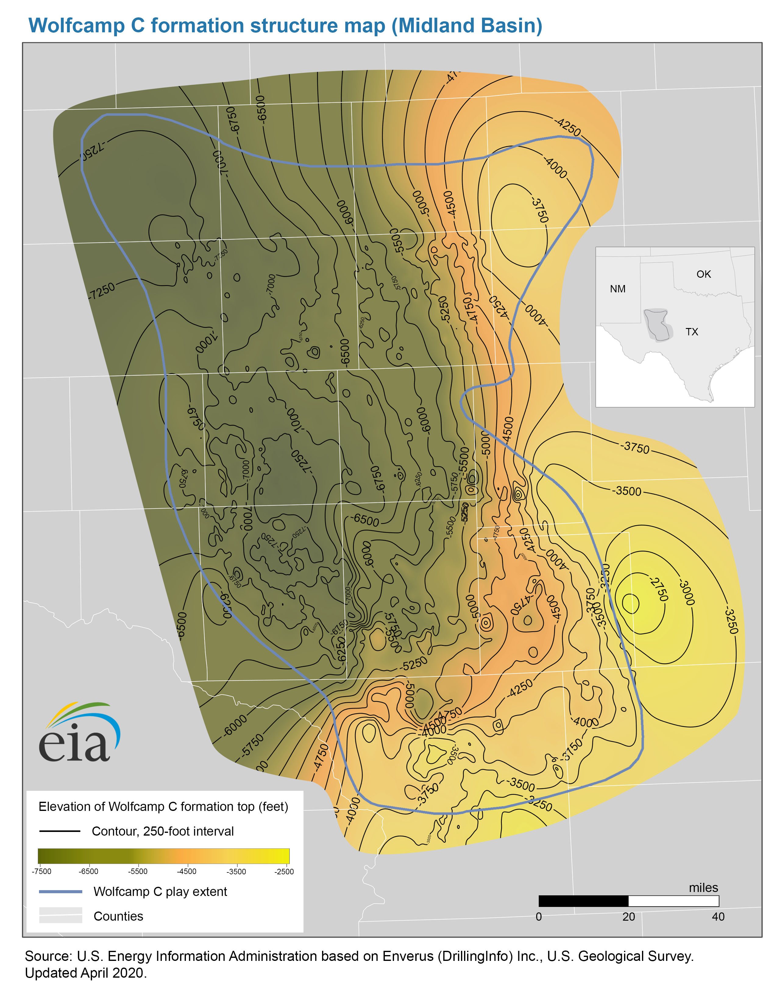
- Structure map of the Wolfcamp C formation, Midland Basin
- Release date: April 23, 2020
- Available formats: PDF JPG
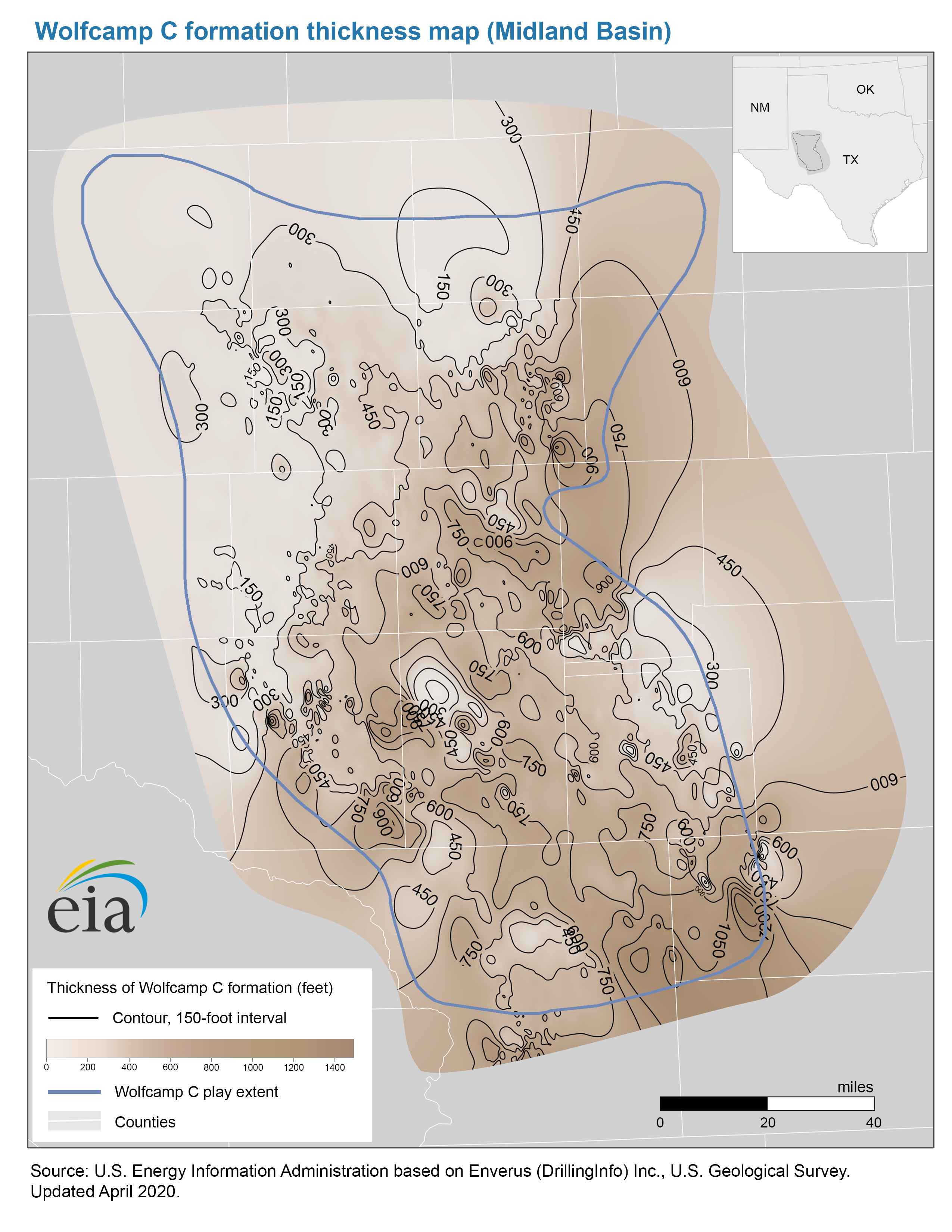
- Thickness map of the Wolfcamp C formation, Midland Basin
- Release date: April 23, 2020
- Available formats: PDF JPG
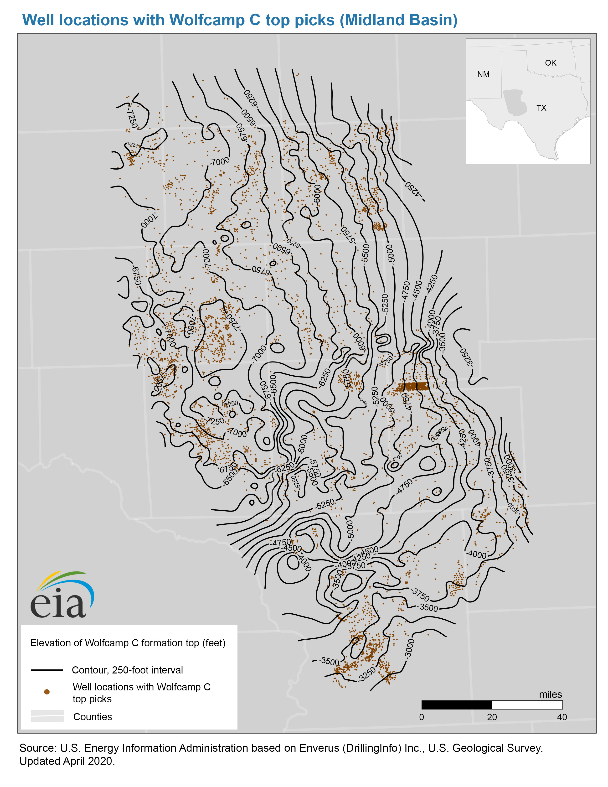
- Well locations with Wolfcamp C top picks map, Midland Basin
- Release date: October 8, 2020
- Available formats: PDF JPG
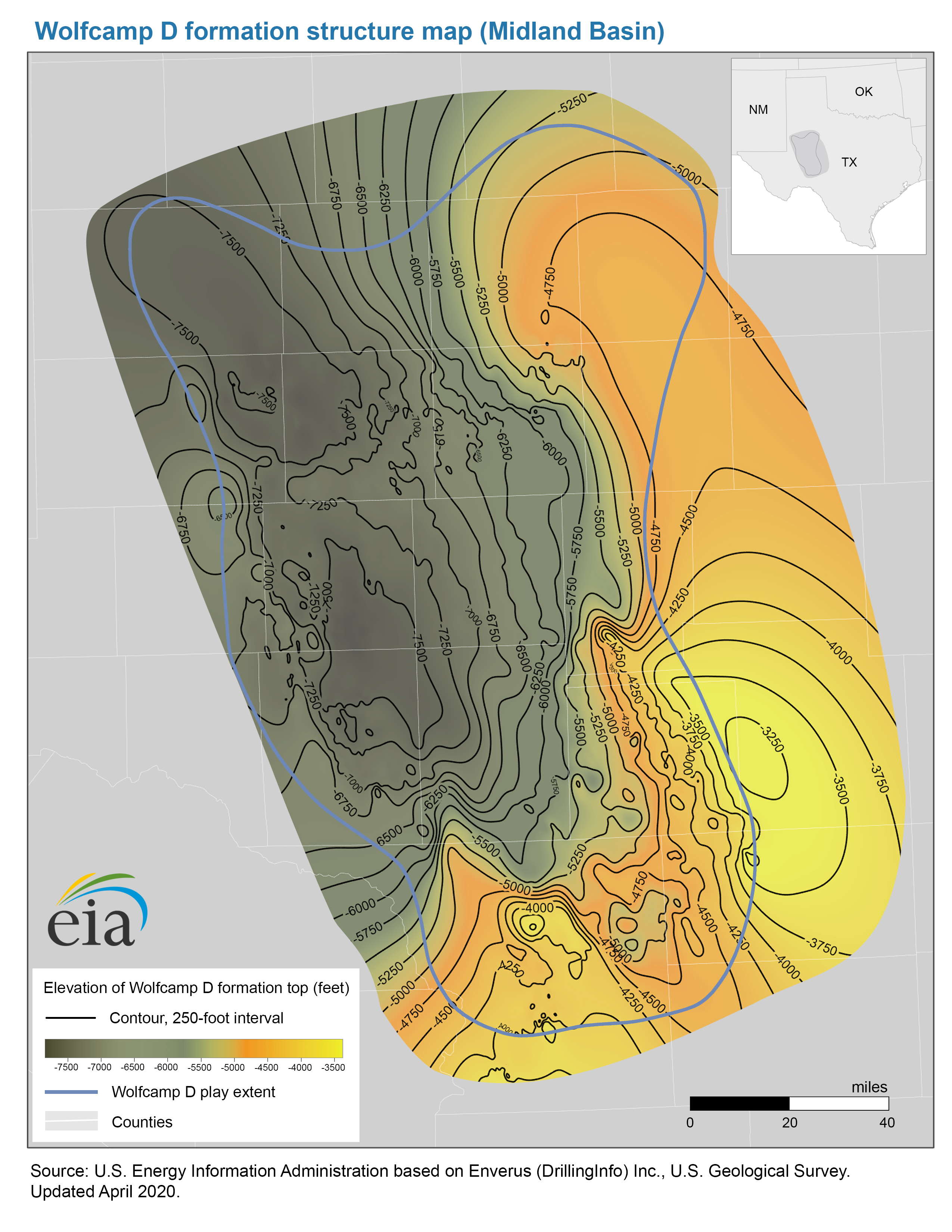
- Structure map of the Wolfcamp D formation, Midland Basin
- Release date: April 23, 2020
- Available formats: PDF JPG
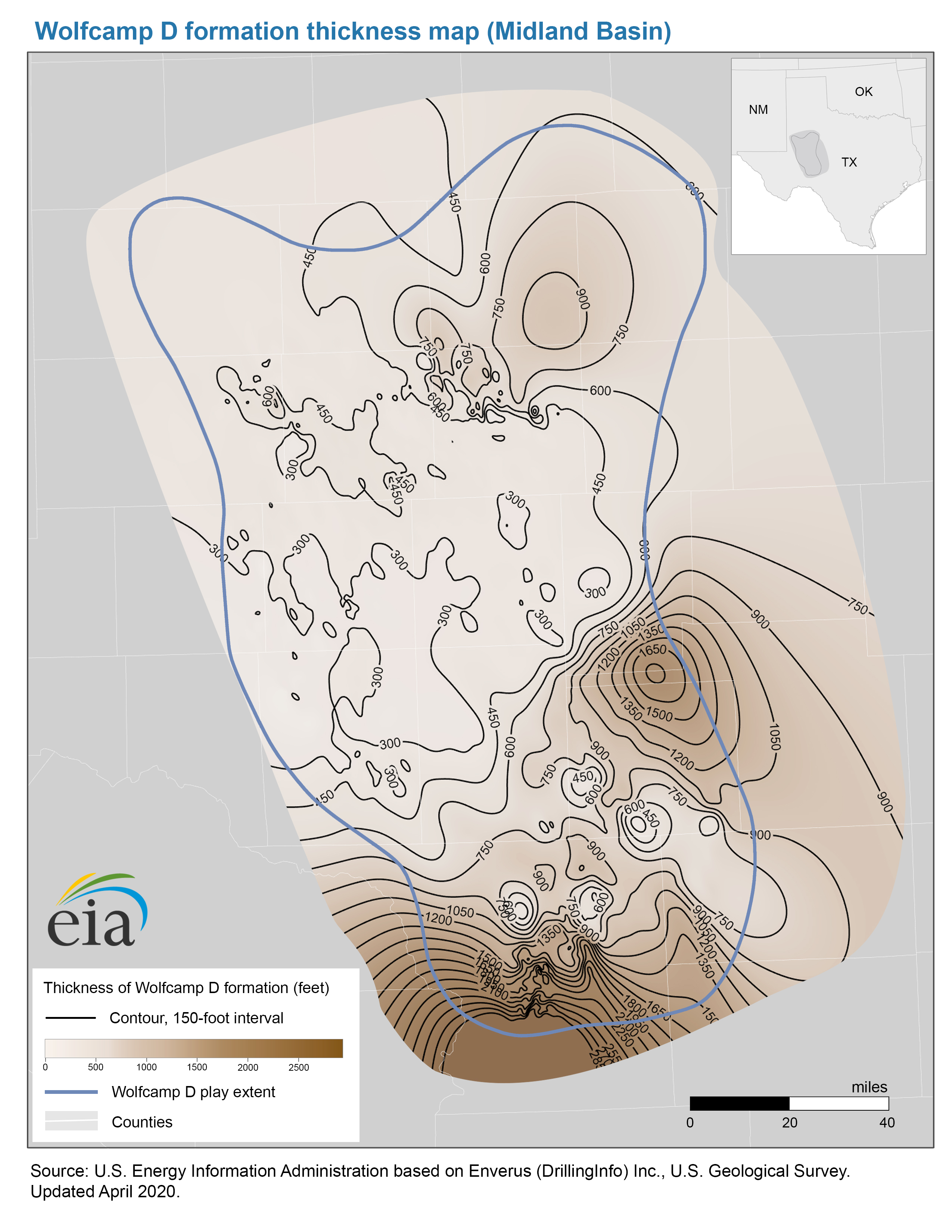
- Thickness map of the Wolfcamp D formation, Midland BasinThickness map of the Wolfcamp D formation, Midland Basin
- Release date: April 23, 2020
- Available formats: PDF JPG
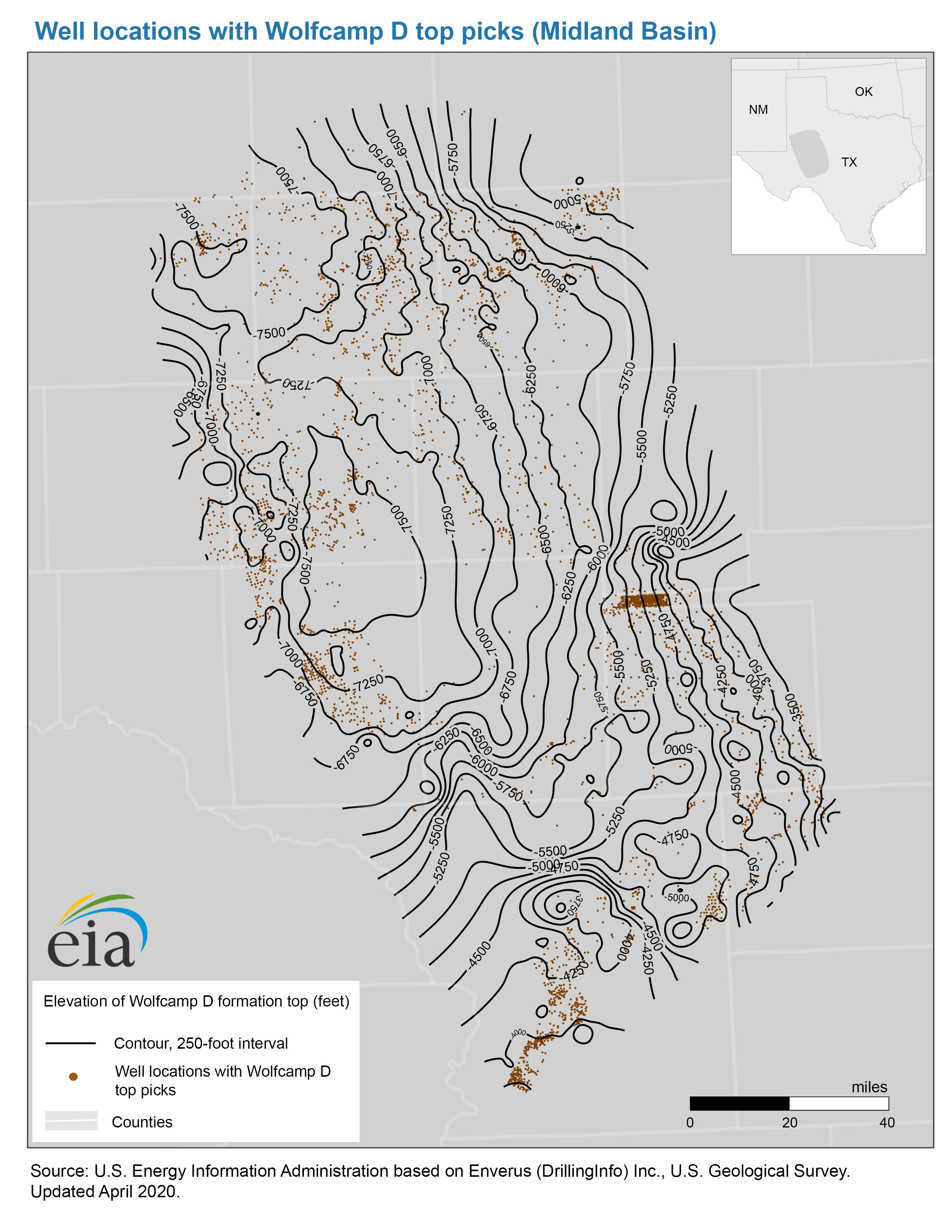
- Well locations with Wolfcamp D top picks map, Midland Basin
- Release date: October 8, 2020
- Available formats: PDF JPG
- Map data
- Wolfcamp A, B, C, and D formation structure and isopachs, Midland Basin
- Release date: April 23, 2020
- Available formats: Shapefile
- Wolfcamp A, B, C, and D play boundaries, Midland Basin
- Release date: June 4, 2020
- Available formats: Shapefile
Rocky Mountain Sedimentary System (Basins: Denver, Greater Green River, Park, Powder River), MT, WY, UT, CO, NE, and NM
- Map data
- Niobrara play boundaries, structure and isopachs
- Release date: March 11, 2016
- Available formats: Shapefile
Texas-Louisiana Salt Basin (TX, LA, MS)
- Haynesville-Bossier Shale Play
- Release date: June 1, 2011
- Available formats: PDF
Western Gulf Basin (TX)
- Eagle Ford Play Report: geology review and map updates
- Release date: December 29, 2014
- Available formats: PDF
- Eagle Ford Shale Play
- Release date: December 29, 2014
- Available formats: PDF
- History animation: Eagle Ford shale production, 2006-2010
- Release date: September 30, 2011
- Available formats: ZIP
- Map data
- Eagle Ford play boundaries, structure and isopachs
- Release date: March 11, 2016
- Available formats: Shapefile
Williston Basin (MT, ND, SD)
- Bakken Shale Play, North Dakota, Montana, Saskatchewan & Manitoba
- Release date: March 20, 2011
- Available formats: PDF
- History animation: Bakken shale production, 1985-2010
- Release date: September 30, 2011
- Available formats: ZIP
- Map data
- Bakken and Three Forks play boundaries, structure, and isopachs
- Release date: March 11, 2016
- Available formats: Shapefile
Oil and Natural Gas Exploration, Resources, and Production
Pre-2010 U.S. oil and natural gas field maps
- Top 100 U.S. Oil and Natural Gas Fields by 2009 Proved Reserves
- Release date: December 7, 2010
- Available formats: PDF
- Top 100 U.S. Oil Fields by 2009 Proved Reserves
- Release date: December 7, 2010
- Available formats:PDF
- Top 100 U.S. Natural Gas Fields by 2009 Proved Reserves
- Release date: December 7, 2010
- Available formats:PDF
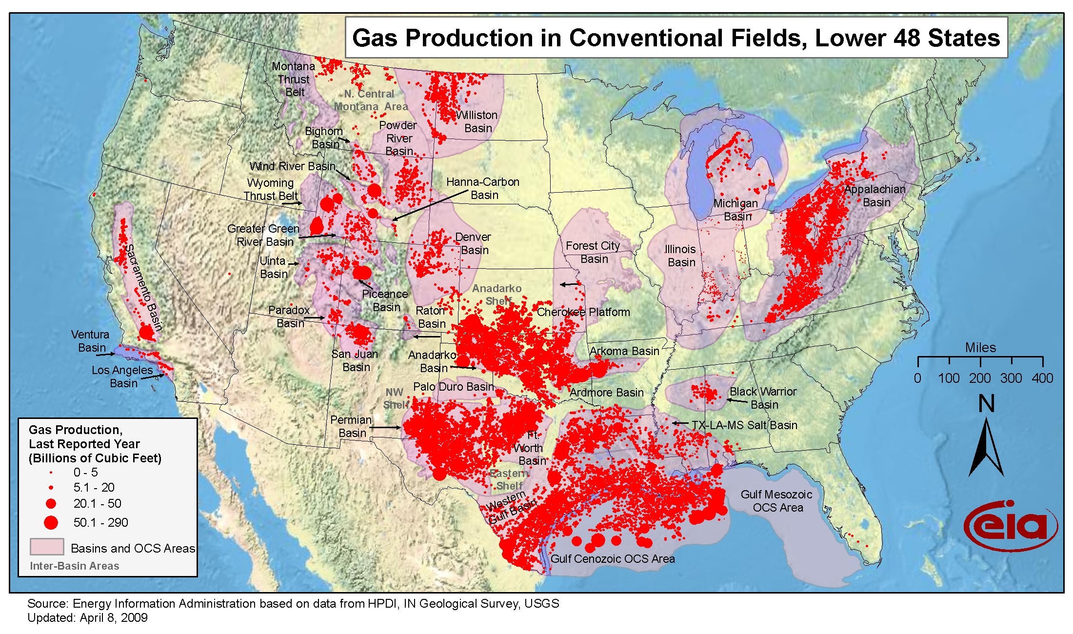
- Gas production in conventional fields, Lower 48 States
- Release date: April 8, 2009
- Available formats: PDF JPG
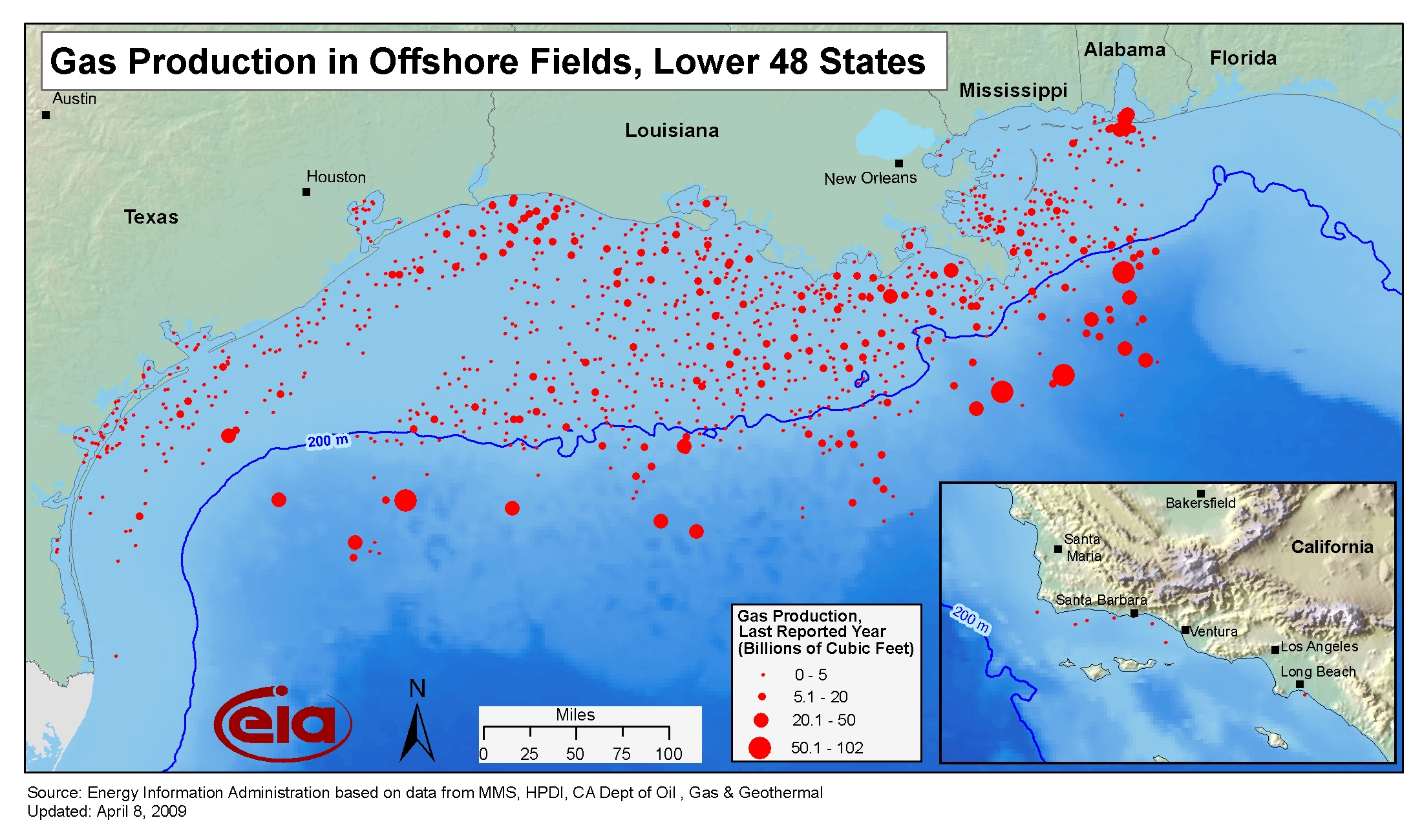
- Gas production in offshore fields, Lower 48 States
- Release date: April 8, 2009
- Available formats: PDF JPG
Detailed oil and natural gas field maps at year end 2001
The detailed field maps below contain locations, boundaries, names, and either the barrel-of-oil equivalent (BOE) or the liquid hydrocarbon (crude oil plus lease condensate) or the natural gas reserve size classes of the known oil and natural gas fields in selected geologically defined areas of the U.S. at year-end 2001. This Index of Detailed Field Maps visually shows the below listed oil and natural gas field maps.
Multiple map sheets were required to adequately portray the fields of some areas. Pursuant to Section 604 of the Energy Policy and Conservation Act, these maps are one product of a joint Department of the Interior, Department of Energy, and Department of Agriculture study of access to oil and natural gas resources located on Federal onshore lands. The maps conform to that ongoing study's temporal, areal, and technical requirements.
Note that most of the maps are large format (60 inches X 36 inches, for example) and are intended for printing on a wide-bed printer. To clearly view them on your monitor you will have to zoom in and then scroll through the map.
Appalachian Basin
- Western New York
- Available formats: BOE Liquids Natural gas
- Northern Ohio, Southwestern New York, and Western Pennsylvania
- Available formats: BOE Liquids Natural gas
- Eastern Pennsylvania
- Available formats: BOE Liquids Natural gas
- Southern Ohio, Southwestern Pennsylvania, and Northwestern West Virginia
- Available formats: BOE Liquids Natural gas
- Eastern West Virginia and Western Maryland
- Available formats: BOE Liquids Natural gas
- Southern West Virginia and Southwestern Virginia
- Available formats: BOE Liquids Natural gas
- Kentucky and Tennessee
- Available formats: BOE Liquids Natural gas
Black Warrior Basin
- Available formats: BOE Liquids Natural gas
South Florida Peninsula
- Available formats: BOE Liquids Natural gas
Alaska's Cook Inlet
- Available formats: BOE Liquids Natural gas
Alaskan North Slope
- Available formats: BOE Liquids Natural gas
National Petroleum Reserve-Alaska and Arctic National Wildlife Refuge 1002 Area
- Available formats: BOE Liquids Natural gas
Eastern Oregon and Washington
- Available formats: BOE Liquids Natural gas
Ventura Basin
- East Part
- Available formats: BOE Liquids Natural gas
- West and Central Parts
- Available formats: BOE Liquids Natural gas
Montana Thrust Belt
- Available formats: BOE Liquids Natural gas
Williston Basin
- Northeast Part
- Available formats: BOE Liquids Natural gas
- Northwest Part
- Available formats: BOE Liquids Natural gas
- South Part
- Available formats: BOE Liquids Natural gas
Wyoming Thrust Belt
- Available formats: BOE Liquids Natural gas
Eastern Great Basin
- Available formats: BOE Liquids Natural gas
Powder River Basin
- Northern Part
- Available formats: BOE Liquids Natural gas
- Southern Part
- Available formats: BOE Liquids Natural gas
Greater Green River Basin
- Available formats: BOE Liquids Natural gas
Uinta-Piceance Basin
- Available formats: BOE Liquids Natural gas
Paradox-San Juan Basin
- Northwest Part
- Available formats: BOE Liquids Natural gas
- Southeast Part
- Available formats: BOE Liquids Natural gas
Denver Basin
- Northern Part
- Available formats: BOE Liquids Natural gas
- Middle Part
- Available formats: BOE Liquids Natural gas
- South Part
- Available formats: BOE Liquids Natural gas
Shapefiles for detailed oil and gas field maps
- Powder River, Greater Green River, Uinta-Piceance, and Paradox-San Juan Basins plus Shapefile for the Montana Thrust Belt
- Available formats: Shapefile
- Appalachian Basin
- Available formats: Shapefile
- Black Warrior Basin, Denver Basin, Wyoming Thrust Belt, National Petroleum Reserve-Alaska plus the Arctic National Wildlife Refuge 1002 Area, and the South Florida Peninsula
- Available formats: Shapefile
- Eastern Great Basin, Eastern Oregon and Washington, Alaskan North Slope, Alaska's Cook Inlet, Ventura Basin, and Williston Basin
- Available formats: Shapefile
EIA's oil and gas field Boundary Generation Scripts
The following Word® (.doc) files provide and describe three script codes conceived, developed, and implemented by EIA to (a) automatically and efficiently generate geologically reasonable oil and gas field boundaries from well data, and then (b) calculate the percentage of Federal land within the each field's boundary. The scripts are coded in Visual Basic® for use in conjunction with ArcGIS® software.
Scripts
- Well Buffering Script
- Available formats: DOC
- Field Outline Smoothing Script
- Available formats: DOC
- Smoothing Tool for ArcGIS 10.0
- Release date: June 1, 2011
- Available formats: ZIP
- Federal Land Percentage Calculation Script
- Available formats: DOC
Application of the decision procedure specified in the Federal Geographic Data Committee's Guidelines for Providing Appropriate Access to Geospatial Data in Response to Security Concerns to the geospatial data provided via this web page resulted in a finding that safeguarding of these data is unwarranted.
Oil and Natural Gas Exploration, Resources, and Production
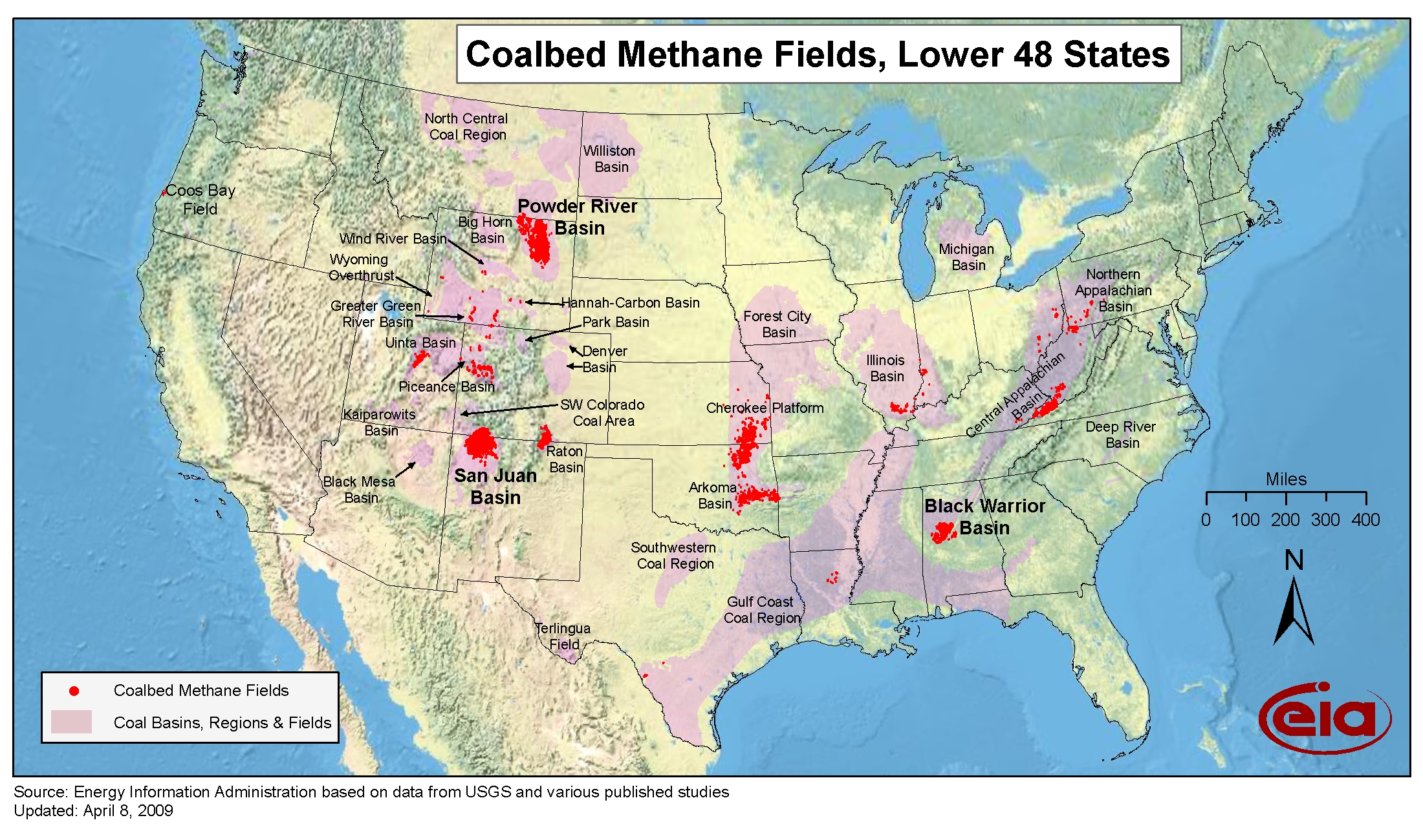
Historical U.S. coalbed methane maps
- Panel 1: Coalbed methane status map (large format 60”x 36”)
- Release date: July 2007
- Available formats: PDF
- Panel 2: Coalbed Methane Past, Present, and Future (large format, 36”x 24”)
- Release date: November 2007
- Available formats: ZIP
- Map data
- Field boundaries (2007), resources (2006), reserves and production (2006), and top 100 methane emitting coal mines (2005)
- Available formats: Shapefile
Application of the decision procedure specified in the Federal Geographic Data Committee's Guidelines for Providing Appropriate Access to Geospatial Data in Response to Security Concerns to the geospatial data provided via this web page resulted in a finding that safeguarding of these data is unwarranted.
-
Map-related Today in Energy articles
- Coal distributions for non-electric power use decline in the South
- May 4, 2026
- Alaska proved reserves increased in 2024, while nationwide proved reserves fell
- April 29, 2026
- The 9th U.S. liquefied natural gas export terminal, Golden Pass, ships first cargo
- April 23, 2026
- What’s in your gasoline? Understanding U.S. motor gasoline formulations
- April 15, 2026
- All 587 related articles