West Virginia, southwest Pennsylvania form an integrated natural gas production region
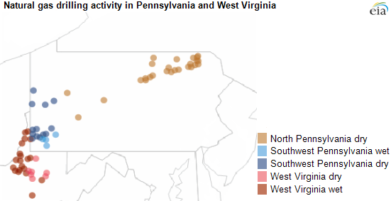
Note: The map shows the location of drilling rigs in the Appalachian basin on August 20, 2013. The Appalachian basin includes both the Marcellus and Utica shale plays. Rigs include those drilling in areas with oil, gas, or both. Dry and wet regions of West Virginia and Pennsylvania based on classifications from Bentek Energy, LLC.
Republished September 9, 2013, to correct an error in the map.
West Virginia and southwest Pennsylvania form an integrated region when it comes to natural gas drilling, with rig operators often moving between the two states. Well drilling has become increasingly focused in these areas of the Appalachian Basin.
The map above shows the current location of natural gas-directed drilling rigs using data from DrillingInfo. The location of these rigs is classified into wet and dry areas of Pennsylvania and West Virginia based on boundaries determined by Bentek Energy, LLC.
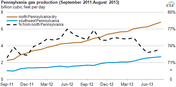
Drilling continues to shift out of the dry region of northeast Pennsylvania, where most natural gas production in the Appalachian Basin's Marcellus Shale play has occurred. For the week ending August 16, 2013, there were 26 active rigs drilling natural gas wells in the northeast Pennsylvania dry region, compared with 43 rigs for the week ending August 17, 2012, and 83 rigs for the week ending August 19, 2011, according to data from Baker Hughes. The share of natural gas production from the southwestern parts of Pennsylvania has grown, exceeding 2 billion cubic per day in February 2013, and as a result, northeastern Pennsylvania's share of total state production fell from nearly 76% in August 2012 to about 73% in August 2013.
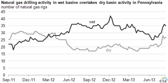
Combining Baker Hughes' rig data with Bentek's boundaries for wet and dry natural gas areas in Pennsylvania and West Virginia shows that the number of gas-directed rigs in Appalachia's wet regions surpassed the number of gas-directed rigs in the dry regions starting early in 2012. As part of this shift, drilling activity has increasingly moved from northern Pennsylvania to southwest Pennsylvania and West Virginia—or from dry to more liquids-rich parts of the Appalachian Basin (see chart below). Increases have also occurred in the number of oil-directed rigs in this region, particularly in the Utica Shale formation.
Note: Dry and wet regions of West Virginia and Pennsylvania based on classifications from Bentek Energy, LLC.