
U.S. ENERGY INFORMATION ADMINISTRATION
WASHINGTON DC 20585
FOR IMMEDIATE RELEASE
August 6, 2014
EIA mapping tool shows which U.S. energy facilities are in areas at risk of flooding
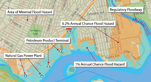
The public now has a new online tool to help inform them about energy facilities' exposure to flooding caused by hurricanes, overflowing rivers, flash floods, and other wet-weather events. Developed by the U.S. Energy Information Administration (EIA), the Flood Vulnerability Assessment Map, shows which power plants, oil refineries, crude oil rail terminals, and other critical energy infrastructure are in areas vulnerable to coastal and inland flooding.
The mapping tool combines EIA's existing U.S. Energy Mapping System with flood hazard information from the Federal Emergency Management Agency (FEMA) and represents EIA's latest step in making energy data more accessible, understandable, relevant, and responsive to users' needs.
"Because energy is vital to the U.S. economy and the everyday lives of Americans, it is important to understand flooding risk to our nation's energy infrastructure," said EIA Administrator Adam Sieminski. "This tool will help users better understand these risks."
To determine if a specific area is vulnerable to flooding, users can type an address, town, or county name in the "find address" box on the mapping system or can zoom in on areas of the United States highlighted with flood hazard information.
The Flood Vulnerability Assessment Map is available at:
http://www.eia.gov/special/floodhazard/
EIA Program Contact: Mark Elbert, 202-586-1185, mark.elbert@eia.gov
EIA Press Contact: Jonathan Cogan, 202-586-8719, jonathan.cogan@eia.gov
EIA-2014-07