Much of the country’s refinery capacity is concentrated along the Gulf Coast
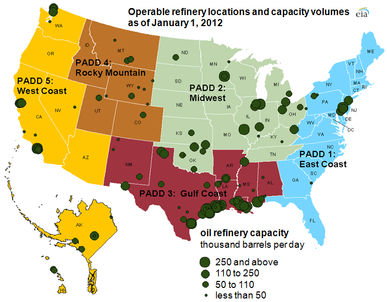
Note: Click map for larger image. Refinery locations are approximate, reflecting the coordinates of the refinery's city, rather than the refinery itself. PADDs are Petroleum Administration for Defense Districts.
Of the more than 17.3 million barrels per day (bbl/d) of refinery capacity located in the United States as of January 1, 2012, about 44% (or nearly 7.7 million bbl/d) is located along the Gulf Coast. As the map above indicates, there are a number of refineries, some of them very large, situated along the coasts of Texas, Louisiana, Mississippi, and Alabama.
The U.S. Energy Information Administration's annual Refinery Capacity Report provides capacity information about individual refineries as of January 1 each year. The report identifies refineries that are operable at the beginning of each year. Operable refineries are further classified as either operating or idle. A refinery could be idle for a number of reasons including routine maintenance, unplanned maintenance, or market conditions.
The Refinery Capacity Report also identifies refineries that were new, reactivated, or shut down in the previous calendar year, as well as refineries that were sold in the previous calendar year. The report includes detailed information about the atmospheric crude oil distillation capacity at each refinery and the capacities for several important downstream refinery units that are used to process the products coming from the atmospheric crude oil distillation unit for further processing.
Many refineries are located close to crude oil production centers such as the Gulf Coast (which has significant volumes of crude oil produced both onshore and offshore); near destinations for importing crude oil; or near major population centers where much of the refineries' output will be needed (e.g., California and the areas near Philadelphia, New York City, and Chicago).
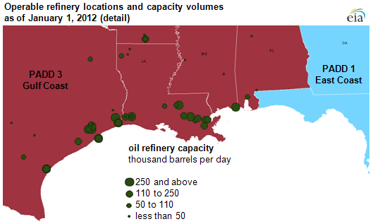
Note: Refinery locations are approximate, reflecting the coordinates of the refinery's city, rather than the refinery itself. PADDs are Petroleum Administration for Defense Districts.
Tags: capacity, crude oil, Gulf Coast, liquid fuels, Louisiana, map, oil/petroleum, refinery capacity, refining, Texas